Home > Europe > United Kingdom > England > Yorkshire > Sheffield
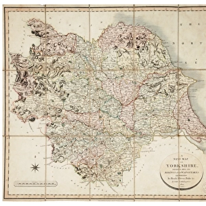
Bacon's large scale plan of Sheffield, c.1890s

![]()
Wall Art and Photo Gifts from Sheffield City Archives
Bacon's large scale plan of Sheffield, c.1890s
Published by G W Bacon & Co Ltd. c. 1890s.
Scale [7.4 inches : 1 mile].
Shows Borough wards.
Dimensions of original: 70 x 55 cm.
Original at Sheffield Libraries: y15494
Sheffield City Archives and Local Studies Library has an unrivalled collection of images of Sheffield, England
Media ID 35983909
© Sheffield City Council - All Rights Reserved
Maps Plans Sheffield Yorkshire
FEATURES IN THESE COLLECTIONS
> Europe
> United Kingdom
> England
> Yorkshire
> Sheffield
> Maps and Charts
> Related Images
> Sheffield City Archives
> Maps and Plans
> Maps of Sheffield
> Sheffield City Archives
> Maps and Plans
EDITORS COMMENTS
This stunning large-scale plan of Sheffield, published by G.W. Bacon & Co. Ltd. in the 1890s, offers a detailed and captivating view of the city during an era of significant growth and industrial development. The map, which measures 70 x 55 cm, was created at a scale of 7.4 inches to 1 mile, providing an accurate representation of the city's layout. At the time, Sheffield was a bustling industrial hub, renowned for its steel production and cutlery manufacturing. The plan meticulously depicts the city's borough wards, including the densely populated areas surrounding the River Don and the sprawling industrial estates to the north. The intricate details of the map reveal the location of various factories, mills, and workshops, as well as residential areas, parks, and churches. The plan also highlights the city's extensive transport network, with the main roads and tramlines clearly marked. The Sheffield and Midland Railway Station, a significant hub for the city's transportation, is prominently featured. The map also shows the city's green spaces, such as the Norfolk Park and the Botanical Gardens, providing a welcome respite from the industrial landscape. This historic map offers a fascinating glimpse into Sheffield's past, providing valuable insights into the city's development during the late Victorian era. Today, it serves as an essential resource for historians, urban planners, and anyone interested in the history of Sheffield and its industrial heritage. The original map is preserved at Sheffield Libraries and Archives, allowing future generations to explore and learn from this rich piece of local history.
MADE IN THE USA
Safe Shipping with 30 Day Money Back Guarantee
FREE PERSONALISATION*
We are proud to offer a range of customisation features including Personalised Captions, Color Filters and Picture Zoom Tools
SECURE PAYMENTS
We happily accept a wide range of payment options so you can pay for the things you need in the way that is most convenient for you
* Options may vary by product and licensing agreement. Zoomed Pictures can be adjusted in the Cart.