Home > Sheffield City Archives > Maps and Plans > Sheffield OS maps
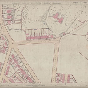
Ordnance Survey Map, Ellesmere Road / Lyons Road area of Sheffield, 1889 (Yorkshire sheet number 294. 4. 18)
")
![]()
Wall Art and Photo Gifts from Sheffield City Archives
Ordnance Survey Map, Ellesmere Road / Lyons Road area of Sheffield, 1889 (Yorkshire sheet number 294. 4. 18)
This map features:
Top left: Earldom Street, Grimesthorpe Road, Lyons Road, The Hills, Malton Street, Burngreave Cemetery, Hooton Street, Lucas Street, Normanton Street.
Bottom left: Earldom Street, Grimesthorpe Road, Danville Street, Danville Terrace, Normanton Hotel Public House, Catherine Road, Buckenham Road, Brighton Villas, Rose Terrace, Regent Villas, Hopewell Villas, Albert Villas, Ellesmere Road.
Top right: Lyons Road, Grimesthorpe Road, Ellesmere Road, Broom Ley, Sedan Street, Kingston Street, Lyons Street Sutherland Road, Petre Street, Edgar Street, Horbury Vilas, Kingston Place, All Saints Church [All Saints School, Burngreave] Playground, York Villas, Carlton Villas, Bamford Villas, Gladstone Grove, Kingston Villas, Clifton Place, Clinton Place, Sutherland Place.
Bottom right: Ellesmere Road, Sutherland Road, Petre Street, Edgar Street, Gladstone Grove, Kingston Villas, Earldom Street, Harlestone Street, Earsham Street, Thorndon Road, Writtle Street, Earldom Place, Belgrave Villas, Ellesmere Villas, Primitive Methodist Chapel [Petre Street Methodist Church].
Dimensions of original 77 x 102 cm.
Scale 10.56 feet : 1 mile [1:500].
From an original at Sheffield Libraries: q00041 (sheet number 294.4.18)
Sheffield City Archives and Local Studies Library has an unrivalled collection of images of Sheffield, England
Media ID 24121350
© Sheffield City Council - All Rights Reserved
Burngreave Old Map Os Maps Sheffield Yorkshire
EDITORS COMMENTS
This print showcases the Ordnance Survey Map of the Ellesmere Road / Lyons Road area in Sheffield, dating back to 1889. The map, with Yorkshire sheet number 294.4.18, offers a fascinating glimpse into the city's past. In the top left corner of the map, we can spot notable landmarks such as Earldom Street, Grimesthorpe Road, and Burngreave Cemetery. Moving towards the bottom left section reveals more streets like Danville Street and Catherine Road, along with charming residential areas like Brighton Villas and Regent Villas. The top right portion highlights Lyons Road and Ellesmere Road while featuring Broom Ley and All Saints Church Playground nearby. Kingston Place and Carlton Villas add character to this part of town. As we explore further into the bottom right quadrant of the map, we encounter Sutherland Road and Petre Street alongside Gladstone Grove and Earldom Street. Notably present is the Primitive Methodist Chapel (Petre Street Methodist Church), adding a touch of historical significance to this neighborhood. Measuring an impressive 77 x 102 cm in its original form, this detailed map provides a scale ratio of 10.56 feet:1 mile (1:500). Preserved at Sheffield Libraries under reference q00041 (sheet number 294.4.18), it offers an invaluable resource for those interested in studying Sheffield's urban development over time.
MADE IN THE USA
Safe Shipping with 30 Day Money Back Guarantee
FREE PERSONALISATION*
We are proud to offer a range of customisation features including Personalised Captions, Color Filters and Picture Zoom Tools
SECURE PAYMENTS
We happily accept a wide range of payment options so you can pay for the things you need in the way that is most convenient for you
* Options may vary by product and licensing agreement. Zoomed Pictures can be adjusted in the Cart.