Home > North America > United States of America > Maps
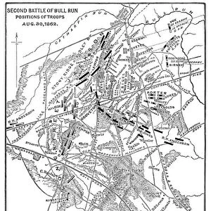
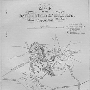
Map of the Battle of Bull Run

![]()
Wall Art and Photo Gifts from Fine Art Storehouse
Map of the Battle of Bull Run
Vintage engraving of a Map of the Battle of Bull Run, The Century Magazine, 1884
Unleash your creativity and transform your space into a visual masterpiece!
duncan1890
Media ID 13609275
© This content is subject to copyright
American Civil War Battle Battlefield Civil War Confederate Army Document Eastern Usa Equipment Information Equipment Mid Atlantic Usa Military Navigational Equipment North America Paper Based Equipment Plan Printed Media Styles The Americas Virginia Us State Wartime Battle Of Bull Run
FEATURES IN THESE COLLECTIONS
> Arts
> Literature
> Magazines
> Fine Art Storehouse
> History
> Battles & Wars
> American Civil War (1860-1865)
> Fine Art Storehouse
> History
> Battles & Wars
> Historcal Battle Maps and Plans
> Fine Art Storehouse
> Map
> Historical Maps
> Fine Art Storehouse
> Map
> USA Maps
> Maps and Charts
> Early Maps
> North America
> United States of America
> Maps
> North America
> United States of America
> Virginia
> Related Images
EDITORS COMMENTS
This vintage engraving of a Map of the Battle of Bull Run takes us back to a pivotal moment in American history. Published in The Century Magazine in 1884, this print captures the essence of the American Civil War era. The intricate details on this paper-based equipment showcase the artistry and precision that went into creating navigational tools during wartime. The Battle of Bull Run, also known as the First Battle of Manassas, was fought on July 21,1861, in Prince William County, Virginia. This historic battle marked one of the earliest major engagements between Union and Confederate forces. As we study this engraved map today, it serves as a valuable document providing insights into military strategies employed during that time. The image transports us to Eastern USA's mid-Atlantic region where brave soldiers clashed on these very grounds over a century ago. It reminds us how far our nation has come since those turbulent times while honoring those who fought for their beliefs. As an antique piece from the past, this archival print holds immense historical significance. Its presence evokes nostalgia for simpler styles and printed media prevalent during the 19th century. A testament to human ingenuity and determination amidst conflict, this artwork stands as a reminder of our shared heritage and serves as an educational tool for future generations seeking to understand America's complex history.
MADE IN THE USA
Safe Shipping with 30 Day Money Back Guarantee
FREE PERSONALISATION*
We are proud to offer a range of customisation features including Personalised Captions, Color Filters and Picture Zoom Tools
SECURE PAYMENTS
We happily accept a wide range of payment options so you can pay for the things you need in the way that is most convenient for you
* Options may vary by product and licensing agreement. Zoomed Pictures can be adjusted in the Cart.