Home > Asia > Georgia > Maps
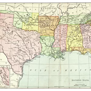
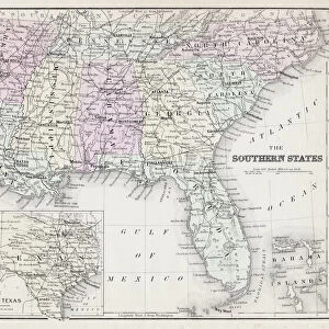
1806, Cary Map of Florida, Georgia, North Carolina, South Carolina and Tennessee

![]()
Wall Art and Photo Gifts from Liszt Collection
1806, Cary Map of Florida, Georgia, North Carolina, South Carolina and Tennessee
1806, Cary Map of Florida, Georgia, North Carolina, South Carolina and Tennessee, John Cary, 1754 - 1835, English cartographer
Liszt Collection of nineteenth-century engravings and images to browse and enjoy
Media ID 14004897
© Artokoloro Quint Lox Limited
1754 1835 1754 – 1835 17541835 1806 English Cartographer Georgia John Cary North Carolina Antique Map Atlas Chart Geographic Latitude Longitude Mappa Mundi Old Antique Plan Old Antique View Old Map Ols Antique Map Rare Old Maps Topo
FEATURES IN THESE COLLECTIONS
> Maps and Charts
> Early Maps
> Maps and Charts
> World
EDITORS COMMENTS
This print showcases the intricate details of the 1806 Cary Map, a masterpiece created by John Cary, an esteemed English cartographer. Spanning across Florida, Georgia, North Carolina, South Carolina, and Tennessee, this map offers a fascinating glimpse into the geographical landscape of these regions during that time. The topography is meticulously depicted with precision and accuracy. Every contour and elevation is intricately captured to provide a comprehensive understanding of the land's features. The grid lines representing latitude and longitude further enhance its navigational utility. As an ancient artifact steeped in history, this vintage map transports us back to an era when exploration and discovery were at their peak. Its aged appearance adds a touch of nostalgia while evoking a sense of wonder about past civilizations' journeys through these lands. With its decorative elements and artistic flair, this old antique plan serves as both an educational tool for geography enthusiasts and a stunning piece of art for collectors. It invites viewers on a visual journey through time as they explore the region's historical significance. Whether displayed in homes or offices, this rare gem from the Liszt Collection sparks curiosity about our world's rich heritage while reminding us of how far we have come in terms of cartography and technological advancements.
MADE IN THE USA
Safe Shipping with 30 Day Money Back Guarantee
FREE PERSONALISATION*
We are proud to offer a range of customisation features including Personalised Captions, Color Filters and Picture Zoom Tools
SECURE PAYMENTS
We happily accept a wide range of payment options so you can pay for the things you need in the way that is most convenient for you
* Options may vary by product and licensing agreement. Zoomed Pictures can be adjusted in the Cart.