Home > Animals > Birds > Passerines > Larks > Related Images
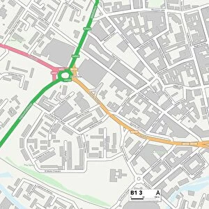
Birmingham B14 5 Map

![]()
Wall Art and Photo Gifts from Map Marketing
Birmingham B14 5 Map
Postcode Sector Map of Birmingham B14 5
Media ID 19965293
Alcester Road Bells Lane Birmingham Broad Lane Broom Drive Denver Road Dial Close Edward Road Glenavon Road Hawkhurst Road Lark Close Lavender Close Maypole Close Myrtle Avenue Pound Road St Judes Close The Laurels
FEATURES IN THESE COLLECTIONS
> Animals
> Birds
> Passerines
> Larks
> Related Images
> Animals
> Mammals
> Muridae
> Heath Mouse
> Europe
> United Kingdom
> England
> Birmingham
> Area
> Maypole
> Europe
> United Kingdom
> England
> London
> Politics
> Edward Heath
> Europe
> United Kingdom
> Wales
> Carmarthenshire
> Whitland
> Map Marketing
> Postcode Sector Maps
> B - Birmingham
> Maps and Charts
> Related Images
MADE IN THE USA
Safe Shipping with 30 Day Money Back Guarantee
FREE PERSONALISATION*
We are proud to offer a range of customisation features including Personalised Captions, Color Filters and Picture Zoom Tools
SECURE PAYMENTS
We happily accept a wide range of payment options so you can pay for the things you need in the way that is most convenient for you
* Options may vary by product and licensing agreement. Zoomed Pictures can be adjusted in the Cart.