Home > Europe > United Kingdom > England > Herefordshire > Maps
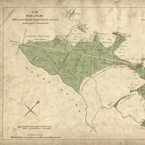
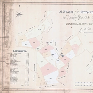
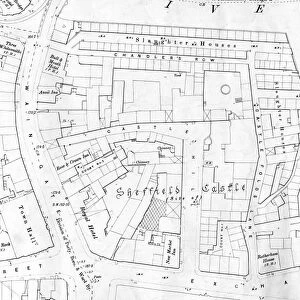
Ecclesall Inclosure (enclosure) Map No. I - Crookesmoor, Little Sheffield, Little Sheffield Moor, 1788
 Map No. I - Crookesmoor, Little Sheffield, Little Sheffield Moor, 1788")
![]()
Wall Art and Photo Gifts from Sheffield City Archives
Ecclesall Inclosure (enclosure) Map No. I - Crookesmoor, Little Sheffield, Little Sheffield Moor, 1788
Scale 10 chains : 1.6 inches.Surveyor: William Fairbank. Copy drawn by J R Wigfull, 1918.Original at Sheffield Local Studies Library:s 3 L
Sheffield City Archives and Local Studies Library has an unrivalled collection of images of Sheffield, England
Media ID 14050478
© Sheffield City Council
Broad Brook Broomhall Chesterfield Crookes Ecclesall Hill Jessop Lane Little Maps Moor Norfolk Porter Road Sheffield Street Button Cumberland Hereford Rockingham
FEATURES IN THESE COLLECTIONS
> Europe
> United Kingdom
> England
> Cumberland
> Europe
> United Kingdom
> England
> Herefordshire
> Maps
> Europe
> United Kingdom
> England
> Norfolk
> Related Images
> Maps and Charts
> Related Images
> Sheffield City Archives
> Maps and Plans
EDITORS COMMENTS
This print showcases the Ecclesall Inclosure Map No. I, dating back to 1788. The map, meticulously surveyed by William Fairbank and later reproduced by J R Wigfull in 1918, offers a fascinating glimpse into the historical landscape of Crookesmoor, Little Sheffield, and Little Sheffield Moor. With a scale of 10 chains to 1.6 inches, this detailed map reveals the intricate network of roads and streets that once weaved through these areas. From Broad Lane to Chesterfield Street, Tudor Road to Cumberland Hill, every name on this map carries a rich history waiting to be explored. The names etched onto the map evoke images of a vibrant community thriving amidst picturesque surroundings. Broomhall, Clarkehouse, Hereford - each place holds its own story within the fabric of Sheffield's past. As our eyes wander across the lines and contours drawn with precision by Fairbank and Wigfull's skilled hands, we can almost envision bustling markets and lively gatherings that once animated these streets. Preserved at the Sheffield Local Studies Library as an invaluable piece of heritage (s3 L), this original document serves as a testament to the city's commitment towards preserving its history for future generations. As we delve into this remarkable snapshot from yesteryears' Sheffield City Archives collection (not affiliated with any company or commercial use), let us take a moment to appreciate how far we have come while cherishing the roots that continue to shape our present-day communities.
MADE IN THE USA
Safe Shipping with 30 Day Money Back Guarantee
FREE PERSONALISATION*
We are proud to offer a range of customisation features including Personalised Captions, Color Filters and Picture Zoom Tools
SECURE PAYMENTS
We happily accept a wide range of payment options so you can pay for the things you need in the way that is most convenient for you
* Options may vary by product and licensing agreement. Zoomed Pictures can be adjusted in the Cart.