Home > Europe > United Kingdom > England > Derbyshire > Dronfield
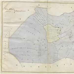
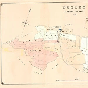
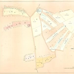
Ordnance Survey map: Totley, 1876

![]()
Wall Art and Photo Gifts from Sheffield City Archives
Ordnance Survey map: Totley, 1876
Scale: 25 inches to 1 mile.
Original at Sheffield Local Studies Library: Derbyshire sheet XI.15.
Includes: Hallfield Farm, Totley Range, Roundseats Farm, quarry, Townhead in Dronfield, Redcar Brook
Sheffield City Archives and Local Studies Library has an unrivalled collection of images of Sheffield, England
Media ID 14050576
© Sheffield City Council
Avenue Brook Derbyshire Dronfield Facilities Farm Lane Maps Moor Road Sheffield Sports Street Dike Hillfoot Quarries Ranges Redcar Totley Townhead
FEATURES IN THESE COLLECTIONS
> Europe
> United Kingdom
> England
> Derbyshire
> Dronfield
> Maps and Charts
> Related Images
> Sheffield City Archives
> Maps and Plans
> Maps of Derbyshire
EDITORS COMMENTS
Step back in time with this fascinating Ordnance Survey map print of Totley from 1876. With a scale of 25 inches to 1 mile, this detailed map provides a glimpse into the past, showcasing the rich history and development of the area. Housed at Sheffield Local Studies Library, this original Derbyshire sheet XI. 15 offers an invaluable resource for researchers and history enthusiasts alike. Explore landmarks such as Hallfield Farm, Roundseats Farm, and Totley Range – a rifle range that played a significant role in local sports and recreational activities during that era. The inclusion of Townhead in Dronfield highlights the close connection between these neighboring communities. Additionally, Redcar Brook is prominently featured on the map, reminding us of its importance as a natural waterway shaping the landscape. As you examine this historical document, take note of other notable features such as quarries scattered throughout the region. These quarries were instrumental in providing materials for construction projects during that time. Immerse yourself in streets like Blacka Moor Hillfoot Avenue or Old Hay Lane; each road tells its own story within this intricate tapestry of Totley's past
MADE IN THE USA
Safe Shipping with 30 Day Money Back Guarantee
FREE PERSONALISATION*
We are proud to offer a range of customisation features including Personalised Captions, Color Filters and Picture Zoom Tools
SECURE PAYMENTS
We happily accept a wide range of payment options so you can pay for the things you need in the way that is most convenient for you
* Options may vary by product and licensing agreement. Zoomed Pictures can be adjusted in the Cart.
![Woodthorpe [Holmsfield], Dronfield, Derbyshire, 1741](/sq/716/woodthorpe-holmsfield-dronfield-derbyshire-14045377.jpg.webp)
![Map of Woodthorpe Hall Farm [Holmesfield] in the parish of Dronfield, County of Derby, 1736](/sq/716/map-woodthorpe-hall-farm-holmesfield-parish-18987347.jpg.webp)