Home > Europe > United Kingdom > England > London > Towns > Hither Green
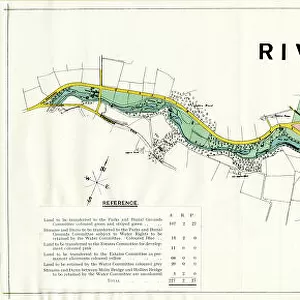
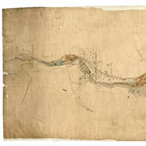
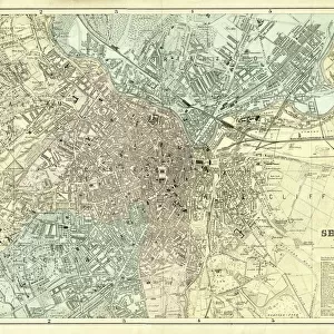
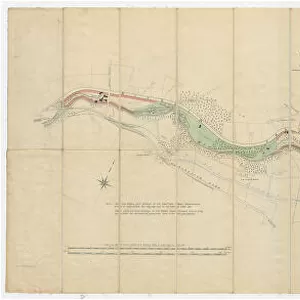
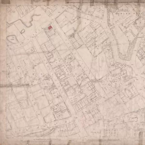
Contoured plan of Rivelin Valley Road, Sheffield, Yorkshire, c. 1900

![]()
Wall Art and Photo Gifts from Sheffield City Archives
Contoured plan of Rivelin Valley Road, Sheffield, Yorkshire, c. 1900
Full title: Contoured plan of Rivelin Valley Road shewing land belonging to the Sheffield Water Department, c. 1900
From an original at Sheffield Libraries: arc02953
Scale 25 inches : 1 mile.
Surveyor: L. M. S. Marsh, Water Engineer.
Lithographers: Pawson and Brailsford.
The line edged pink belongs to the Sheffield Water Department and is available for laying out in building sites, etc. That coloured blue [actually green on the map?] belongs to the Water Department but is only available for recreation grounds and similar purposes.
From Rivelin Mill Bridge in the west to Holme Lane Bridge in the east.
Reading left to right:
Rivelin Mill Bridge
Mill Dam
Rivelin mills
Rails Road
Upper Coppice Wheel
Lower Coppice Wheel
Rivelin Wire Mill
The Coppice
Coppice Farm
Manchester Road
Coppice Wood
Rivelin Glen
Low Coppice House
Paper mill
Coppice House
Wolf Wheel
Tofts Lane
oak Farm
Under Tofts
Rivelin Hotel
Hagg Lane Cottages
Iron Wheel
Glen House
Glen Bridge
Upper Cut Wheel
Den Bank Plantation
Hagg Lane
New Wheel
Little London Wheel
Liberty Hill
Holme Head Wheel
Allotment gardens
Russel Wood
Roscoe Plantation
Roscoe Wheel
Roscoe Bridge
The Hagg
Haggs House
Reaps Wood
Back Lane
Spooners Wheels
Bole Hill Road
Staney Wood
Hollins Bridge Mill
Holly Bush Inn
St Michaels Mortuary Chapel / Roman Catholic Cemetery
Hollins Bridge
Rivelin Road
Walkley Bank Tilt
Mouse Hole Forge
Walkley Bank
Morley Street
Holme Lane Bridge
Malin Bridge
Part of Holme Lane
Part of Loxley New Road
Sheffield City Archives and Local Studies Library has an unrivalled collection of images of Sheffield, England
Media ID 19042530
© Sheffield City Council
FEATURES IN THESE COLLECTIONS
> Animals
> Birds
> Gruiformes
> Rallidae
> Little Wood Rail
> Animals
> Birds
> Gruiformes
> Rallidae
> Water Rail
> Animals
> Insects
> Hemiptera
> Green Scale
> Animals
> Insects
> Hemiptera
> Holly Scale
> Europe
> United Kingdom
> England
> London
> Towns
> Hither Green
> Europe
> United Kingdom
> England
> Manchester
> Manchester
> Europe
> United Kingdom
> England
> Yorkshire
> Holme
> Europe
> United Kingdom
> England
> Yorkshire
> Little London
> Europe
> United Kingdom
> England
> Yorkshire
> Marsh
> Sheffield City Archives
> Maps and Plans
> Maps of Sheffield
EDITORS COMMENTS
This vintage print showcases a contoured plan of Rivelin Valley Road in Sheffield, Yorkshire, dating back to around 1900. The detailed map, titled "Contoured plan of Rivelin Valley Road shewing land belonging to the Sheffield Water Department" provides valuable insight into the city's historical development and infrastructure. Created by surveyor L. M. S. Marsh, who served as the Water Engineer at that time, this map was skillfully lithographed by Pawson and Brailsford. It features a scale of 25 inches to 1 mile, allowing for precise measurements and accurate representation. The pink line on the map indicates land owned by the Sheffield Water Department that is available for potential building sites or other purposes. In contrast, areas colored blue (though appearing green on the map) are designated solely for recreational grounds and similar uses. Spanning from Rivelin Mill Bridge in the west to Holme Lane Bridge in the east, this comprehensive plan highlights various landmarks along Rivelin Valley Road such as mills, bridges, farms, cottages, wheels (used in manufacturing processes), plantations, allotment gardens, and even religious structures like St Michaels Mortuary Chapel/Roman Catholic Cemetery. Preserved within Sheffield Libraries' archives under reference arc02953 from an original source material held at Sheffield City Archives itself (#57863), this print offers a fascinating glimpse into both urban planning history and local water management practices during that era in Yorkshire's vibrant cityscape.
MADE IN THE USA
Safe Shipping with 30 Day Money Back Guarantee
FREE PERSONALISATION*
We are proud to offer a range of customisation features including Personalised Captions, Color Filters and Picture Zoom Tools
SECURE PAYMENTS
We happily accept a wide range of payment options so you can pay for the things you need in the way that is most convenient for you
* Options may vary by product and licensing agreement. Zoomed Pictures can be adjusted in the Cart.