Home > Europe > United Kingdom > England > Yorkshire > Toll Bar
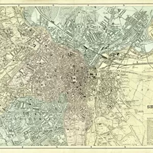
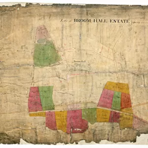
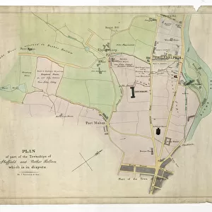
Map of the estate belonging to the late William Wilson, c. 1850

![]()
Wall Art and Photo Gifts from Sheffield City Archives
Map of the estate belonging to the late William Wilson, c. 1850
Full title: Map of the estate belonging to the late William Wilson lying between Sharrow Mills and Endcliffe Wood made to shew to whom each part now belongs, c. 1850.
Wood Field, Long Field, Spring Field, Square Field, Upper Delf Field, Endcliffe Wood, Endcliffe Vale Road, Clarke House Road (sic) later Brocco Bank, Turnpike Road [Ecclesall Road], Occupation Road, Brocco Bank Allotment, Botanic Garden, Nether field, Great Tom Field, Wadbro Close, quarry, Little Tom Field, Brocco Bank Close, River Porter, Lower Delf Field, [Hunters Bar] Toll Bar, Hunter House, Lescar Wheel, Lescar Wheel Road [later Sharrow Vale Road, homestead, [Sharrow Snuff Mills], Walsh Stubbings, The Meadow, Meadow of Walsh Stubbings, Holme Meadow.
[Snuff Mill Lane, Stalker Lees Road, General Cemetery, Rosedale Road, Cemetery Avenue, Harefield Road, Denham Road, Harland Road, Neill Road, Eastwood Road. Meadow Terrace, Clarkehouse Road, Botanical Gardens, Endcliffe Vale Road, Botanical Road, Rossington Road, Wiseton Road, Newington Road, Endliffe Terrace Road, Endcliffe Rise Road, Wilson Road, Dover Road, Wadbrough Road, Southgrove Road, Broomgrove Road, Collegiate Crescent, Thompson Road, Khartoum Road, Walton Road, Bristol Road, Bagshot Street, Bruce Road, Westbrook Bank, Stewart Road, Ratcliffe Road, Jarrow Road, Gordon Road, Lynton Road, Wayland Road, Bowood Road].
Scale 0.5 inch : 1 chain.
Dimensions approx. 78 x 57 cm.
Original at Sheffield Libraries: arc03953
Sheffield City Archives and Local Studies Library has an unrivalled collection of images of Sheffield, England
Media ID 20503349
© Sheffield City Council - All Rights Reserved
Ecclesall Maps Sheffield Yorkshire
FEATURES IN THESE COLLECTIONS
> Arts
> Artists
> W
> William Wilson
> Europe
> United Kingdom
> England
> Bristol
> Bristol
> Europe
> United Kingdom
> England
> Yorkshire
> Holme
> Europe
> United Kingdom
> England
> Yorkshire
> Rossington
> Europe
> United Kingdom
> England
> Yorkshire
> Sheffield
> Europe
> United Kingdom
> England
> Yorkshire
> Street
> Europe
> United Kingdom
> England
> Yorkshire
> Toll Bar
> Europe
> United Kingdom
> England
> Yorkshire
> Walton
> Maps and Charts
> Related Images
> Sheffield City Archives
> Maps and Plans
> Maps of Sheffield
EDITORS COMMENTS
This vintage print showcases a fascinating glimpse into the past with its depiction of the estate belonging to the late William Wilson in 1850. The detailed map, measuring approximately 78 x 57 cm, reveals the intricate layout of this expansive property situated between Sharrow Mills and Endcliffe Wood. The map highlights various fields such as Wood Field, Long Field, Spring Field, Square Field, Upper Delf Field, and Nether field. It also features significant landmarks like Endcliffe Wood and Endcliffe Vale Road. Notable roads are marked including Clarke House Road (later Brocco Bank), Turnpike Road (Ecclesall Road), Occupation Road, and Lescar Wheel Road (later Sharrow Vale Road). Other interesting elements captured on this historical document include the presence of a quarry near Wadbro Close and several meadows like The Meadow and Holme Meadow. Additionally, it identifies important structures within the estate such as Hunter House, Sharrow Snuff Mills, Walsh Stubbings homesteads. Displayed at Sheffield Libraries: arc03953 collection from Sheffield City Archives; this remarkable photograph offers an invaluable insight into the land ownership during that era. Its scale of 0.5 inch to one chain allows for precise measurements while exploring every nook and cranny of William Wilson's estate. With its rich history encapsulated within its borders, this image serves as a testament to both urban development and preservation over time in Sheffield's landscape.
MADE IN THE USA
Safe Shipping with 30 Day Money Back Guarantee
FREE PERSONALISATION*
We are proud to offer a range of customisation features including Personalised Captions, Color Filters and Picture Zoom Tools
SECURE PAYMENTS
We happily accept a wide range of payment options so you can pay for the things you need in the way that is most convenient for you
* Options may vary by product and licensing agreement. Zoomed Pictures can be adjusted in the Cart.
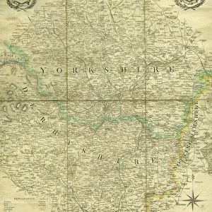
![[South] Part of the West Riding of Yorkshire, 1796](/sq/716/south-west-riding-yorkshire-1796-14047414.jpg.webp)