Home > Europe > United Kingdom > England > Yorkshire > Darnall
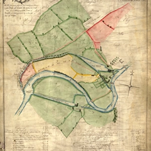
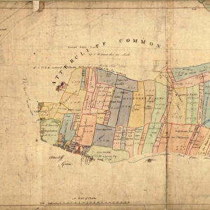
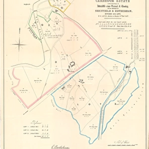
A map of the lands near Attercliffe and Darnall, [?1820s]
![A map of the lands near Attercliffe and Darnall, [?1820s]](/p/716/map-lands-near-attercliffe-darnall-1820s-18396317.jpg.webp "A map of the lands near Attercliffe and Darnall, [?1820s]")
![]()
Wall Art and Photo Gifts from Sheffield City Archives
A map of the lands near Attercliffe and Darnall, [?1820s]
From an original at Sheffield Libraries: arc02686
Sheffield City Archives and Local Studies Library has an unrivalled collection of images of Sheffield, England
Media ID 18396317
© Sheffield City Council - All Rights Reserved
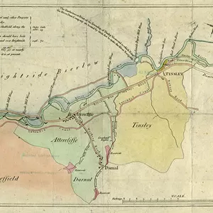
Attercliffe Darnall Sheffield Yorkshire
FEATURES IN THESE COLLECTIONS
> Europe
> United Kingdom
> England
> Yorkshire
> Attercliffe
> Europe
> United Kingdom
> England
> Yorkshire
> Darnall
> Europe
> United Kingdom
> England
> Yorkshire
> Sheffield
> Europe
> United Kingdom
> England
> Yorkshire
> Tinsley
> Maps and Charts
> Related Images
> Sheffield City Archives
> Maps and Plans
> Maps of Sheffield
EDITORS COMMENTS
This print showcases a historical treasure, offering us a glimpse into the past. The image features an intricately detailed map titled "A map of the lands near Attercliffe and Darnall" believed to have been created in the 1820s. Preserved within Sheffield Libraries' archives, this remarkable piece sheds light on the rich history of Sheffield, Yorkshire. The map encompasses various significant locations within its boundaries, including Attercliffe and Darnall. These areas were once bustling centers of industry and trade during the early 19th century. As we explore this snapshot from yesteryears, our eyes are drawn to notable landmarks such as the Tinsley Canal, which played a crucial role in connecting these thriving communities. It is worth noting that this particular map was attributed to Henry Sanderson—a name synonymous with cartography excellence during that era. His meticulous attention to detail is evident in every stroke and contour depicted on this print. As we delve deeper into studying this archival gem, it becomes apparent that it holds immense value for historians, researchers, and enthusiasts alike. Its significance lies not only in documenting geographical information but also in providing insights into how society evolved over time. While commercial use may be restricted for this precious artifact, its true purpose lies in preserving our heritage and fostering a sense of connection with our ancestors who once traversed these very streets. This photograph serves as a reminder of how far we've come while honoring those who paved the way for progress in Sheffield's vibrant
MADE IN THE USA
Safe Shipping with 30 Day Money Back Guarantee
FREE PERSONALISATION*
We are proud to offer a range of customisation features including Personalised Captions, Color Filters and Picture Zoom Tools
SECURE PAYMENTS
We happily accept a wide range of payment options so you can pay for the things you need in the way that is most convenient for you
* Options may vary by product and licensing agreement. Zoomed Pictures can be adjusted in the Cart.