Home > Europe > United Kingdom > England > Norfolk > Bradfield
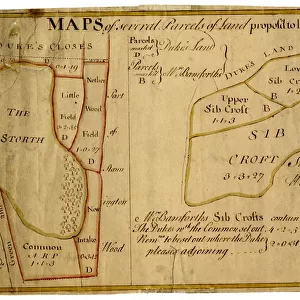
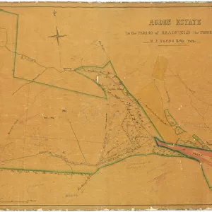
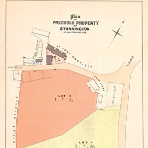
Maps of Several Parcels of Land proposed to be exchanged, Bradfield, [c. 1750 - 1760]
![Maps of Several Parcels of Land proposed to be exchanged, Bradfield, [c. 1750 - 1760]](/p/716/maps-parcels-land-proposed-exchanged-bradfield-19192402.jpg.webp "Maps of Several Parcels of Land proposed to be exchanged, Bradfield, [c. 1750 - 1760]")
![]()
Wall Art and Photo Gifts from Sheffield City Archives
Maps of Several Parcels of Land proposed to be exchanged, Bradfield, [c. 1750 - 1760]
Scale 2 chains : 1 inch [40 inches : 1 mile].
Surveyor: [William Fairbank I].
A proposed exchange between the Duke of Norfolk and Mrs Bamforth.
Includes the Sib Crofts and the Storth, and land near Stannington Wood.
Field names and acreages given on the map and acreages of exchanges listed; boundaries and border coloured.
From an original at Sheffield Libraries: arc03002
Sheffield City Archives and Local Studies Library has an unrivalled collection of images of Sheffield, England
Media ID 19192402
© Sheffield City Council
Bradfield Stannington Yorkshire
FEATURES IN THESE COLLECTIONS
> Europe
> United Kingdom
> England
> Norfolk
> Bradfield
> Europe
> United Kingdom
> England
> Yorkshire
> Sheffield
> Europe
> United Kingdom
> England
> Yorkshire
> Stannington
> Maps and Charts
> Related Images
> Sheffield City Archives
> Maps and Plans
> Maps of Bradfield
EDITORS COMMENTS
This print showcases the intricate "Maps of Several Parcels of Land propos d to be exchanged" in Bradfield, dating back to the mid-18th century. The scale of 2 chains to 1 inch (40 inches to 1 mile) allows for a detailed representation of the area's geography and boundaries. The surveyor behind this remarkable work is none other than William Fairbank I, whose expertise shines through in every meticulously drawn line. This particular map documents a proposed exchange between two prominent figures: the Duke of Norfolk and Mrs Bamforth. It encompasses various notable locations such as the Sib Crofts, the Storth, and land near Stannington Wood. What sets this map apart is its inclusion of field names and acreages for each parcel depicted, providing valuable information about land usage during that era. Additionally, it lists acreages for all exchanges made as part of this proposal. To enhance clarity and distinction, boundaries and borders are thoughtfully colored. Preserved at Sheffield Libraries under reference arc03002 from Sheffield City Archives, this historical gem offers an intriguing glimpse into Yorkshire's past landscape
MADE IN THE USA
Safe Shipping with 30 Day Money Back Guarantee
FREE PERSONALISATION*
We are proud to offer a range of customisation features including Personalised Captions, Color Filters and Picture Zoom Tools
SECURE PAYMENTS
We happily accept a wide range of payment options so you can pay for the things you need in the way that is most convenient for you
* Options may vary by product and licensing agreement. Zoomed Pictures can be adjusted in the Cart.


![A map of Wm. Carrs Farm at Stanington [Stannington], 1747](/sq/716/map-wm-carrs-farm-stanington-stannington-1747-19192400.jpg.webp)
![A survey of a parcel of Land called Platts... [Platts Farm, Ughill], 1728](/sq/716/survey-parcel-land-called-platts-19225923.jpg.webp)