Home > Arts > Artists > W > William Wilson
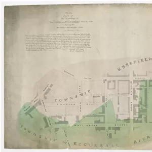
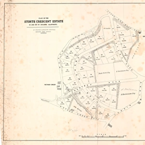
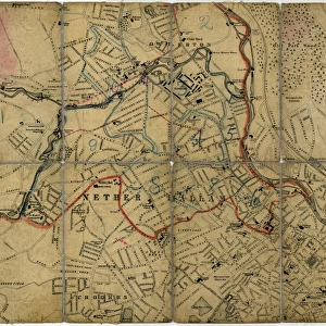
Plan of Ranmoor and Nether Green, Sheffield, 1830

![]()
Wall Art and Photo Gifts from Sheffield City Archives
Plan of Ranmoor and Nether Green, Sheffield, 1830
Full title: Plan of estates at Rand Moor [Ranmoor] and Nether Green in the township of Upper Hallam the property of John Eyre.
Names include Elizabeth Hawkesworth, John Beale, William Andrews, Susannah Ibbotson, George Stringer, Thomas Binney, Jos. Biggin, Hannah Elliott, George Parker, Edmund Wilson, Ebenezer Marsden, Geo. Worrall, William Fox, Mary Trippet, William Wilson.
Shows Water Lane, Porter Bridge, road from Bents Green, road from Whiteley Wood, dam, Porter Wheel, Porter Brook, Ibbotsons Wheel, Ibbotson Wood, Spurgear Wheel Dam, road to Lydgate, road to Sheffield.
From an original at Sheffield Libraries: arc03994
Sheffield City Archives and Local Studies Library has an unrivalled collection of images of Sheffield, England
Media ID 21076340
© Sheffield City Council - All Rights Reserved
FEATURES IN THESE COLLECTIONS
> Arts
> Artists
> W
> William Wilson
> Europe
> United Kingdom
> England
> Yorkshire
> Marsden
> Europe
> United Kingdom
> England
> Yorkshire
> Sheffield
> Maps and Charts
> Related Images
> Sheffield City Archives
> Maps and Plans
> Maps of Sheffield
EDITORS COMMENTS
This print showcases the detailed "Plan of Ranmoor and Nether Green, Sheffield" dating back to 1830. The full title reveals that this plan was specifically created to depict the estates owned by John Eyre in Upper Hallam township. The names associated with these properties include Elizabeth Hawkesworth, John Beale, William Andrews, Susannah Ibbotson, George Stringer, Thomas Binney, Jos. Biggin, Hannah Elliott, George Parker, Edmund Wilson, Ebenezer Marsden, Geo. Worrall, William Fox Mary Trippet and William Wilson. The plan provides a comprehensive overview of the area's landmarks and features such as Water Lane and Porter Bridge. It also highlights important roads leading from Bents Green and Whiteley Wood while showcasing significant elements like dams including Porter Wheel Dam and Spurgear Wheel Dam. Additionally featured are notable locations such as Ibbotsons Wheel and Ibbotson Wood. This historical document is an invaluable resource for researchers interested in understanding the development of Sheffield during this period. Preserved at Sheffield Libraries under reference number arc03994 from Sheffield City Archives ensures its accessibility for future generations seeking insights into the city's rich history
MADE IN THE USA
Safe Shipping with 30 Day Money Back Guarantee
FREE PERSONALISATION*
We are proud to offer a range of customisation features including Personalised Captions, Color Filters and Picture Zoom Tools
SECURE PAYMENTS
We happily accept a wide range of payment options so you can pay for the things you need in the way that is most convenient for you
* Options may vary by product and licensing agreement. Zoomed Pictures can be adjusted in the Cart.