Home > Europe > United Kingdom > England > Yorkshire > Sheffield
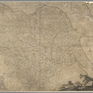
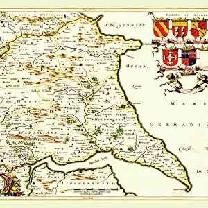
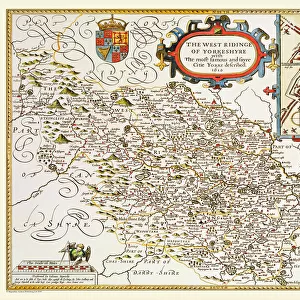
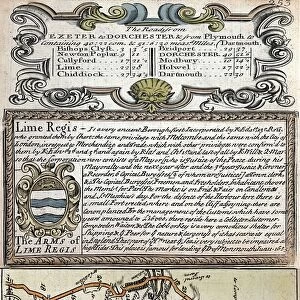
An Accurate Map of the West Riding of Yorkshire, divided into its Wapontakes, 1785

![]()
Wall Art and Photo Gifts from Sheffield City Archives
An Accurate Map of the West Riding of Yorkshire, divided into its Wapontakes, 1785
Drawn from Surveys, with various additional Improvements: Illustrated with Historical Extracts relative to its Natural Produce, Mines, Minerals, Manufactures, Trade and the present state of its Principal Towns.
By Emanuel Bowen.
Scale 20 miles : 4.8 inches.
Size 71 x 53 cm.
Original at Sheffield Libraries: y09345
Sheffield City Archives and Local Studies Library has an unrivalled collection of images of Sheffield, England
Media ID 14046971
© Sheffield City Council
FEATURES IN THESE COLLECTIONS
> Arts
> Artists
> B
> Emanuel Bowen
> Arts
> Artists
> P
> those present
> Europe
> United Kingdom
> England
> Yorkshire
> Sheffield
> Maps and Charts
> Early Maps
> Sheffield City Archives
> Maps and Plans
> Maps of Yorkshire
EDITORS COMMENTS
This print showcases "An Accurate Map of the West Riding of Yorkshire, divided into its Wapontakes" from 1785. The map, drawn by Emanuel Bowen, is a testament to the meticulous surveys and additional improvements made during that time. Measuring at an impressive size of 71 x 53 cm, it offers a detailed representation of the region's natural produce, mines, minerals, manufactures, trade, and the present state of its principal towns. The historical extracts accompanying this map provide valuable insights into the rich heritage and significance of Yorkshire's West Riding. It serves as a window into the past for those seeking to explore and understand this remarkable area. Preserved in Sheffield Libraries' archives under reference number y09345, this original piece holds immense historical value. Its scale is precisely measured at 20 miles : 4.8 inches—allowing viewers to grasp distances accurately within their minds. As one gazes upon this print from Sheffield City Archives, they are transported back in time—a journey through centuries filled with stories waiting to be discovered. Whether you have personal ties to Yorkshire or simply appreciate cartography as an art form and historical resource—the beauty and depth captured within this image will undoubtedly captivate your imagination.
MADE IN THE USA
Safe Shipping with 30 Day Money Back Guarantee
FREE PERSONALISATION*
We are proud to offer a range of customisation features including Personalised Captions, Color Filters and Picture Zoom Tools
SECURE PAYMENTS
We happily accept a wide range of payment options so you can pay for the things you need in the way that is most convenient for you
* Options may vary by product and licensing agreement. Zoomed Pictures can be adjusted in the Cart.