Home > Europe > United Kingdom > England > Yorkshire > Barnsley
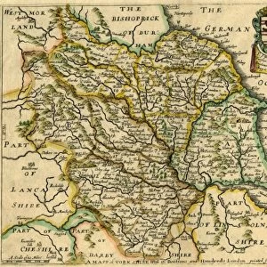
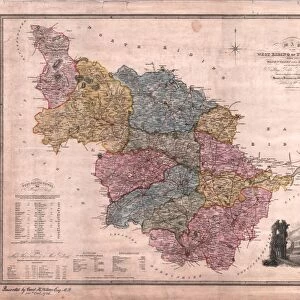
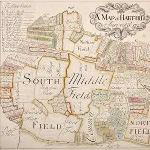
Map of the West Riding of Yorkshire, Richard Blome, 1673

![]()
Wall Art and Photo Gifts from Sheffield City Archives
Map of the West Riding of Yorkshire, Richard Blome, 1673
Full title: A Mapp of the West Ridinge of Yorke-shire; with its wapentakes
Scale 20 miles : 1 inch.
Size 35.5 x 29.5 cm.
Original at Sheffield Local Studies Library: y09347
Sheffield City Archives and Local Studies Library has an unrivalled collection of images of Sheffield, England
Media ID 14047018
© Sheffield City Council
Barnsley Doncaster Maps Rotherham Sheffield Yorkshire Bradford Huddersfield Leeds
FEATURES IN THESE COLLECTIONS
> Europe
> United Kingdom
> England
> Yorkshire
> Barnsley
> Europe
> United Kingdom
> England
> Yorkshire
> Bradford
> Europe
> United Kingdom
> England
> Yorkshire
> Doncaster
> Europe
> United Kingdom
> England
> Yorkshire
> Huddersfield
> Europe
> United Kingdom
> England
> Yorkshire
> Leeds
> Europe
> United Kingdom
> England
> Yorkshire
> Rotherham
> Europe
> United Kingdom
> England
> Yorkshire
> Sheffield
> Maps and Charts
> Related Images
> Sheffield City Archives
> Maps and Plans
> Maps of Yorkshire
EDITORS COMMENTS
This print showcases an exquisite piece of history, the "Map of the West Riding of Yorkshire" by Richard Blome in 1673. With its full title reading "A Mapp of the West Ridinge of Yorke-shire; with its wapentakes" this map offers a fascinating glimpse into the past. Measuring at 35.5 x 29.5 cm and featuring a scale of 20 miles to 1 inch, it is a remarkable testament to cartographic craftsmanship. Preserved within Sheffield Local Studies Library, this treasured artifact provides invaluable insights into the geography and boundaries of Yorkshire's West Riding during that era. From bustling cities like Sheffield, Leeds, Huddersfield, Bradford, Doncaster, Barnsley to Rotherham - all are meticulously depicted on this intricate map. The attention to detail is awe-inspiring as every road and river is intricately illustrated with precision. This historical gem not only serves as a navigational tool but also gives us glimpses into how towns were laid out centuries ago. As we delve into our region's rich heritage through this exceptional print from Sheffield City Archives, let us appreciate the dedication and skill that went into creating such masterpieces in times long gone by. It reminds us that even amidst modern advancements in mapping technology today; there is still something truly magical about holding a tangible piece of history in our hands.
MADE IN THE USA
Safe Shipping with 30 Day Money Back Guarantee
FREE PERSONALISATION*
We are proud to offer a range of customisation features including Personalised Captions, Color Filters and Picture Zoom Tools
SECURE PAYMENTS
We happily accept a wide range of payment options so you can pay for the things you need in the way that is most convenient for you
* Options may vary by product and licensing agreement. Zoomed Pictures can be adjusted in the Cart.