Home > Europe > United Kingdom > England > Yorkshire > Sheffield
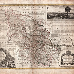
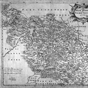
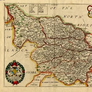
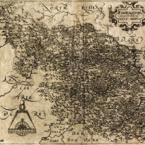
A Mapp (sic) of Yorkshire with its divisions and hundreds by Richard Blome, 1670
 of Yorkshire with its divisions and hundreds by Richard Blome, 1670")
![]()
Wall Art and Photo Gifts from Sheffield City Archives
A Mapp (sic) of Yorkshire with its divisions and hundreds by Richard Blome, 1670
Scale 10 miles : 1.5 inches.Size 28 x 20 cm.Original at Local Studies E 2 S
Sheffield City Archives and Local Studies Library has an unrivalled collection of images of Sheffield, England
Media ID 14047969
© Sheffield City Council
FEATURES IN THESE COLLECTIONS
> Europe
> United Kingdom
> England
> Yorkshire
> Sheffield
> Maps and Charts
> Related Images
> Sheffield City Archives
> Maps and Plans
> Maps of Yorkshire
EDITORS COMMENTS
This print showcases a remarkable piece of history: "A Mapp (sic) of Yorkshire with its divisions and hundreds" by Richard Blome, dating back to 1670. The intricate details and exquisite craftsmanship of this map are truly awe-inspiring. Measuring at 28 x 20 cm, it offers a glimpse into the past when cartography was both an art form and a scientific endeavor. The map's scale is particularly fascinating, with every inch representing an impressive ten miles. This level of precision highlights the dedication and expertise that went into creating such comprehensive geographical records during this era. It allows us to appreciate how much effort was invested in accurately capturing the vast expanse of Yorkshire's landscape. Preserved within Sheffield City Archives' Local Studies collection, this print serves as a window into our region's rich heritage. It provides valuable insights into the historical divisions and hundreds that once shaped Yorkshire's administrative structure. While we admire this stunning artifact for its aesthetic appeal, it also holds immense educational value. Scholars can delve deep into its intricacies to uncover forgotten stories about land ownership, boundaries, or even population distribution from centuries ago. As we explore this print from Sheffield City Archives' collection, let us marvel at the ingenuity behind Richard Blome's work while acknowledging the importance of preserving these invaluable pieces for future generations to cherish and learn from.
MADE IN THE USA
Safe Shipping with 30 Day Money Back Guarantee
FREE PERSONALISATION*
We are proud to offer a range of customisation features including Personalised Captions, Color Filters and Picture Zoom Tools
SECURE PAYMENTS
We happily accept a wide range of payment options so you can pay for the things you need in the way that is most convenient for you
* Options may vary by product and licensing agreement. Zoomed Pictures can be adjusted in the Cart.

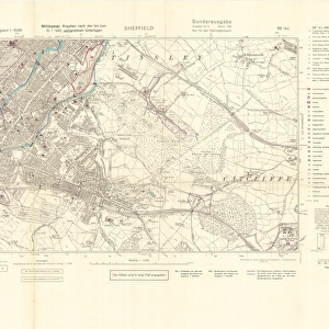
![Map of Sheffield (S[outh]) Woodhouse Rix[s]on, Werksgruppe fur 3 Edelstahlwerke](/sq/716/map-sheffield-south-woodhouse-rixson-14045679.jpg.webp)