Home > Europe > United Kingdom > England > Yorkshire > Sheffield
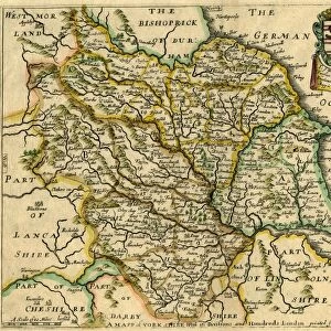
West Riding of Yorkshire, 1645

![]()
Wall Art and Photo Gifts from Sheffield City Archives
West Riding of Yorkshire, 1645
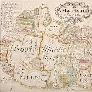
Full title: Yorkshire West Riding - Ducatus Eboracensis Pars Occidentalis, 1645
From an original at Sheffield Libraries: arc00074
Sheffield City Archives and Local Studies Library has an unrivalled collection of images of Sheffield, England
Media ID 14045255
© Sheffield City Council
FEATURES IN THESE COLLECTIONS
> Animals
> Mammals
> Phyllostomidae
> Occidentalis
> Animals
> Mammals
> Pteropodidae
> Occidentalis
> Europe
> United Kingdom
> England
> Yorkshire
> Sheffield
> Maps and Charts
> Related Images
> Sheffield City Archives
> Maps and Plans
> Maps of Yorkshire
West Riding of Yorkshire, 1645 - A Glimpse into the Historical Tapestry
EDITORS COMMENTS
. This print transports us back to the year 1645, offering a fascinating glimpse into the West Riding of Yorkshire's rich history. The full title, 'Yorkshire West Riding - Ducatus Eboracensis Pars Occidentalis, 1645, ' hints at its significance as an invaluable artifact from Sheffield City Archives. The image depicts a meticulously detailed map that showcases the region's western portion during this pivotal era. Every intricate line and delicate stroke on this ancient cartographic masterpiece tells a story of land ownership, boundaries, and settlements in what was once known as one of England's largest counties. As we delve deeper into this historical treasure trove, it becomes evident that this map holds immense value beyond its aesthetic appeal. It serves as a testament to the meticulous craftsmanship and dedication of those who sought to document their surroundings centuries ago. Preserved with utmost care by Sheffield Libraries (arc00074), this print offers an opportunity for modern-day enthusiasts and historians alike to explore the past through geographic lenses. Its presence reminds us of our collective responsibility to safeguard these cultural artifacts for future generations. Let us immerse ourselves in this remarkable visual representation—tracing long-forgotten roads and villages—and appreciate how it connects us with our ancestors' lives in ways words alone cannot convey. This photograph invites contemplation about our roots while celebrating the enduring legacy left behind by those who have shaped our beloved West
MADE IN THE USA
Safe Shipping with 30 Day Money Back Guarantee
FREE PERSONALISATION*
We are proud to offer a range of customisation features including Personalised Captions, Color Filters and Picture Zoom Tools
SECURE PAYMENTS
We happily accept a wide range of payment options so you can pay for the things you need in the way that is most convenient for you
* Options may vary by product and licensing agreement. Zoomed Pictures can be adjusted in the Cart.