Home > Europe > United Kingdom > England > Yorkshire > Sheffield
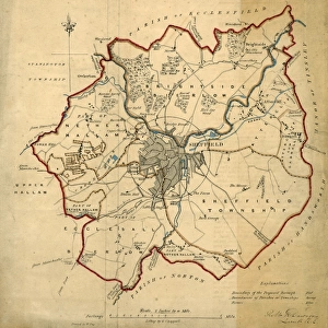
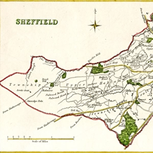
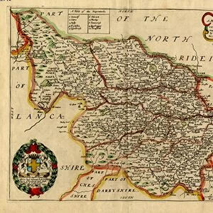
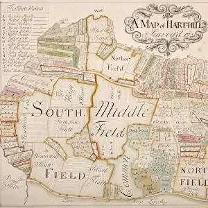
West Riding of Yorkshire by J and C Walker, 1836

![]()
Wall Art and Photo Gifts from Sheffield City Archives
West Riding of Yorkshire by J and C Walker, 1836
Scale 20 miles : 3.3 inches.
Size 38.5 x 31.5 cm
Original at Sheffield Local Studies Library: y11809
Sheffield City Archives and Local Studies Library has an unrivalled collection of images of Sheffield, England
Media ID 14046994
© Sheffield City Council
FEATURES IN THESE COLLECTIONS
> Europe
> United Kingdom
> England
> Yorkshire
> Sheffield
> Maps and Charts
> Related Images
> Sheffield City Archives
> Maps and Plans
> Maps of Yorkshire
EDITORS COMMENTS
This print showcases the picturesque West Riding of Yorkshire, captured by the talented duo J and C Walker in 1836. The intricate details and exquisite craftsmanship of this map are truly remarkable. With a scale of 20 miles to 3.3 inches, it offers a comprehensive view of this historic region. Measuring at an impressive size of 38.5 x 31.5 cm, this print allows viewers to immerse themselves in the beauty and grandeur of Yorkshire's landscape from the comfort of their own homes or offices. Every contour, river, and village is meticulously depicted, providing an invaluable resource for historians, geographers, or anyone with a deep appreciation for cartography. The original copy resides within the esteemed Sheffield Local Studies Library under reference number y11809 – a testament to its significance as part of our cultural heritage. This particular piece holds immense historical value as it not only captures the physical geography but also provides insights into how people perceived and understood their surroundings during that era. While we admire this stunning work without any intention for commercial use or affiliation with the company responsible for its creation, let us take a moment to appreciate the artistry behind it all – an enduring testament to human ingenuity and curiosity about our world's diverse landscapes throughout history.
MADE IN THE USA
Safe Shipping with 30 Day Money Back Guarantee
FREE PERSONALISATION*
We are proud to offer a range of customisation features including Personalised Captions, Color Filters and Picture Zoom Tools
SECURE PAYMENTS
We happily accept a wide range of payment options so you can pay for the things you need in the way that is most convenient for you
* Options may vary by product and licensing agreement. Zoomed Pictures can be adjusted in the Cart.