Home > Europe > United Kingdom > England > Yorkshire > Sheffield
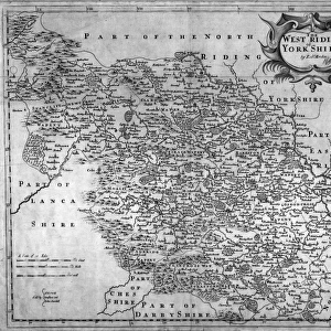
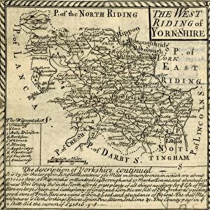
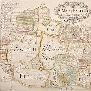
The West Ridinge of Yorkeshyre (Yorkshire) c. 1610
 c. 1610")
![]()
Wall Art and Photo Gifts from Sheffield City Archives
The West Ridinge of Yorkeshyre (Yorkshire) c. 1610
Full title: The West Ridinge of Yorkeshyre with the most famous and fayre Citie of Yorke described 1610 Performed by Johan Speede and are to be sold by Thomas Bassett in Fleet Street, and by Richard Chilwell in St. Pauls Church Yard
Original at Sheffield Libraries: arc00072
Sheffield City Archives and Local Studies Library has an unrivalled collection of images of Sheffield, England
Media ID 14045142
© Sheffield City Council
FEATURES IN THESE COLLECTIONS
> Europe
> United Kingdom
> England
> Yorkshire
> Sheffield
> Europe
> United Kingdom
> England
> Yorkshire
> Street
> Maps and Charts
> Related Images
> Sheffield City Archives
> Maps and Plans
> Maps of Yorkshire
EDITORS COMMENTS
This print showcases "The West Ridinge of Yorkeshyre" as it appeared in 1610, a true testament to the rich history and beauty of Yorkshire. Created by Johan Speede and made available for sale through Thomas Bassett in Fleet Street and Richard Chilwell in St. Pauls Church Yard, this intricate map offers a fascinating glimpse into the past. With its full title proudly displayed, "The West Ridinge of Yorkeshyre with the most famous and fayre Citie of Yorke described 1610" this print serves as an invaluable historical artifact. It not only provides a detailed depiction of the region's landscape but also highlights the prominence of York City during that era. Preserved at Sheffield Libraries under reference arc00072, this remarkable piece transports us back to a time when cartography was both an art form and a means for exploration. The meticulous attention to detail is evident in every stroke, capturing the essence of Yorkshire's diverse topography. As we gaze upon this image, we are reminded of Yorkshire's enduring charm – from its rolling hills to its bustling city streets. This print invites us to delve into centuries-old tales woven within these lands; stories that have shaped Yorkshire's identity over time. While appreciating this photograph from Sheffield City Archives, let us acknowledge its significance beyond commercial use. Instead, let it serve as a reminder that our heritage should be cherished and preserved for future generations to explore and appreciate their roots.
MADE IN THE USA
Safe Shipping with 30 Day Money Back Guarantee
FREE PERSONALISATION*
We are proud to offer a range of customisation features including Personalised Captions, Color Filters and Picture Zoom Tools
SECURE PAYMENTS
We happily accept a wide range of payment options so you can pay for the things you need in the way that is most convenient for you
* Options may vary by product and licensing agreement. Zoomed Pictures can be adjusted in the Cart.