Home > Maps and Charts > Related Images
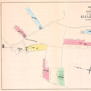
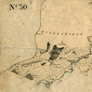
Particulars and conditions of sale of valuable freehold properties situate at or near Chapeltown and Ecclesfield, 1866

![]()
Wall Art and Photo Gifts from Sheffield City Archives
Particulars and conditions of sale of valuable freehold properties situate at or near Chapeltown and Ecclesfield, 1866
Full details of each lot are given in the sale particulars.Scale 3 chains : 1 inch.Fowler and Son, Sheffield.Loxley Brothers, Lithographers, Sheffield.Sheffield Local Studies Library: Sale Plans 3 Jul 1866
Sheffield City Archives and Local Studies Library has an unrivalled collection of images of Sheffield, England
Media ID 14051421
© Sheffield City Council
Ecclesfield Lane Maps Nether Plans Chapeltown
FEATURES IN THESE COLLECTIONS
> Maps and Charts
> Related Images
> Sheffield City Archives
> Maps and Plans
EDITORS COMMENTS
This print from 1866 showcases the "Particulars and conditions of sale of valuable freehold properties situate at or near Chapeltown and Ecclesfield". With its intricate details, this historical document provides a fascinating glimpse into the past. The sale particulars meticulously outline each lot, offering potential buyers a comprehensive understanding of the properties on offer. The scale of 3 chains to 1 inch ensures that every minute detail is accurately represented in this print. Created by Fowler and Son, Sheffield, and beautifully lithographed by Loxley Brothers, this piece exemplifies the craftsmanship prevalent during that era. Housed in the Sheffield Local Studies Library, this rare gem serves as an invaluable resource for researchers delving into local history. Its significance lies not only in its depiction of Chapeltown and Ecclesfield but also in shedding light on property sales practices prevalent during the Victorian era. As you explore this image, allow yourself to be transported back to a time when these areas were bustling with activity. Discover how Nether Lane intersected with other streets while examining maps and plans associated with Chapeltown and Ecclesfield. Immerse yourself in their rich heritage while appreciating the meticulous attention given to preserving such historical artifacts
MADE IN THE USA
Safe Shipping with 30 Day Money Back Guarantee
FREE PERSONALISATION*
We are proud to offer a range of customisation features including Personalised Captions, Color Filters and Picture Zoom Tools
SECURE PAYMENTS
We happily accept a wide range of payment options so you can pay for the things you need in the way that is most convenient for you
* Options may vary by product and licensing agreement. Zoomed Pictures can be adjusted in the Cart.