Home > Maps and Charts > Related Images
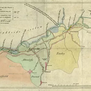
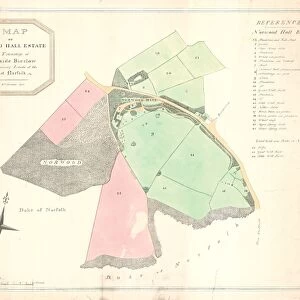
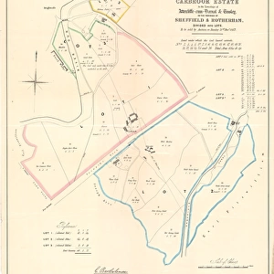
Plan of the Carbrook Estate as proposed to be laid out in allotments, for the Sheffield, Attercliffe and Carbrook Freehold Land Society. Geo W. Wilson, surveyor, etc. 1853

![]()
Wall Art and Photo Gifts from Sheffield City Archives
Plan of the Carbrook Estate as proposed to be laid out in allotments, for the Sheffield, Attercliffe and Carbrook Freehold Land Society. Geo W. Wilson, surveyor, etc. 1853
Original at Sheffield Archives: FrC/96 (FrC/12/3)
Sheffield City Archives and Local Studies Library has an unrivalled collection of images of Sheffield, England
Media ID 14049873
© Sheffield City Council
Attercliffe Brightside Carbrook Hall Houses Housing Maps River Rivers Road Street Dunlop
FEATURES IN THESE COLLECTIONS
> Maps and Charts
> Related Images
> Sheffield City Archives
> Maps and Plans
EDITORS COMMENTS
This print showcases the intricate "Plan of the Carbrook Estate" as envisioned by the Sheffield, Attercliffe and Carbrook Freehold Land Society in 1853. The mastermind behind this remarkable layout is none other than Geo W. Wilson, a skilled surveyor who left an indelible mark on this ambitious project. The image transports us back to a time when urban planning was still in its infancy, yet brimming with potential. The map depicts a meticulously designed network of allotments that were intended to transform the Carbrook area into a thriving community. Rows of charming houses line Dunlop Street, offering glimpses into the lives of those who would call this place home. Nature intertwines seamlessly with human habitation as we observe the meandering River Don gracefully flowing through this picturesque landscape. It serves not only as an aesthetic feature but also provides sustenance and connectivity for both residents and visitors alike. Notably absent from our narrative is any mention of commercial use or profit-driven endeavors associated with this land development scheme. Instead, our attention is drawn towards creating a harmonious living environment where individuals can thrive amidst nature's embrace. Preserved within Sheffield City Archives, this historic photograph offers us insight into an era characterized by visionary thinking and progressive urban planning ideals. It stands as a testament to the dedication and foresight displayed by those involved in shaping Sheffield's vibrant history.
MADE IN THE USA
Safe Shipping with 30 Day Money Back Guarantee
FREE PERSONALISATION*
We are proud to offer a range of customisation features including Personalised Captions, Color Filters and Picture Zoom Tools
SECURE PAYMENTS
We happily accept a wide range of payment options so you can pay for the things you need in the way that is most convenient for you
* Options may vary by product and licensing agreement. Zoomed Pictures can be adjusted in the Cart.
![The Duke of Norfolks estates in Brightside Bierlow, Sheffield, [mid 19th cent]](/sq/716/duke-norfolks-estates-brightside-bierlow-20355002.jpg.webp)