Home > Maps and Charts > Related Images
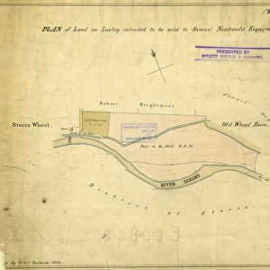
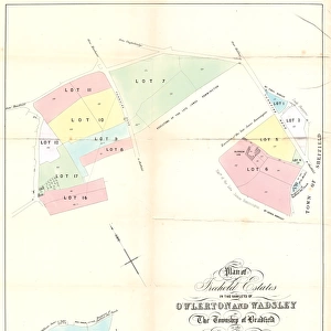
Plan of lands at Wadsley Bridge by The Sheffield Gas Company, 1929

![]()
Wall Art and Photo Gifts from Sheffield City Archives
Plan of lands at Wadsley Bridge by The Sheffield Gas Company, 1929
Original at Local Studies S25S
Sheffield City Archives and Local Studies Library has an unrivalled collection of images of Sheffield, England
Media ID 14048675
© Sheffield City Council
Bridge Company Industry Maps Sheffield Wadsley
FEATURES IN THESE COLLECTIONS
> Maps and Charts
> Related Images
> Sheffield City Archives
> Maps and Plans
EDITORS COMMENTS
This print showcases the intricate "Plan of lands at Wadsley Bridge" meticulously drafted by The Sheffield Gas Company in 1929. Preserved within the esteemed Sheffield City Archives, this historical artifact offers a fascinating glimpse into the city's industrial past. The image depicts an intricately detailed map that highlights the specific areas and boundaries of land owned by The Sheffield Gas Company in Wadsley Bridge during that era. With its precise cartography and meticulous labeling, it serves as a testament to the company's commitment to efficient planning and resource management. Aesthetically pleasing yet laden with historical significance, this print transports us back to a time when gas was a vital component of everyday life. It reminds us of how industries like The Sheffield Gas Company played an integral role in shaping cities like Sheffield through their infrastructure development. Beyond its technical value, this photograph also evokes a sense of nostalgia for those familiar with Wadsley Bridge or passionate about local history. It invites viewers to explore not only the physical landscape but also delve into stories behind each plot marked on the plan. While commercial use is not mentioned here, it is important to recognize that such maps were instrumental in guiding urban expansion and facilitating economic growth during that period. This particular print stands as both an archival treasure and a testament to human ingenuity in mapping out our surroundings for progress and prosperity.
MADE IN THE USA
Safe Shipping with 30 Day Money Back Guarantee
FREE PERSONALISATION*
We are proud to offer a range of customisation features including Personalised Captions, Color Filters and Picture Zoom Tools
SECURE PAYMENTS
We happily accept a wide range of payment options so you can pay for the things you need in the way that is most convenient for you
* Options may vary by product and licensing agreement. Zoomed Pictures can be adjusted in the Cart.