Home > Europe > United Kingdom > Wales > Powys > Montgomery
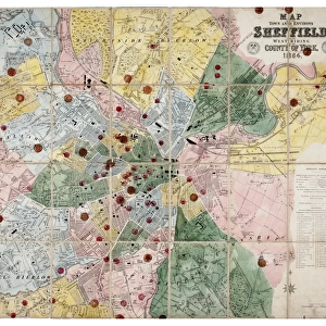
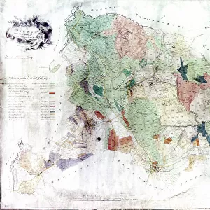
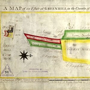
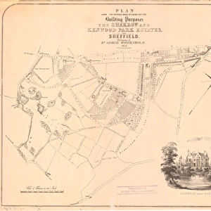
Proposed mode of laying out for building purposes the Sharrow and Kenwood Park Estates near Sheffield belonging to George Wostenholm, 1853

![]()
Wall Art and Photo Gifts from Sheffield City Archives
Proposed mode of laying out for building purposes the Sharrow and Kenwood Park Estates near Sheffield belonging to George Wostenholm, 1853
By Parkin and Bacon.Includes the proposed Kenwood Road and the proposed Montgomery Road. Also shown is the toll bar on the road from Bakewell [Ecclesall Road].Scale 4 chains : 1 inch.Original at Sheffield Local Studies Library:s (21) 1 L
Sheffield City Archives and Local Studies Library has an unrivalled collection of images of Sheffield, England
Media ID 14050502
© Sheffield City Council
Bank Cemetery Club Ecclesall Edge George Hall Highfield Hill House Houses Lane Mill Moor Nether Park Road Sharrow Sheffield South Street Walk Boston Cherry Franklin Kenwood Lansdowne Montgomery Pearl Priory Toll
FEATURES IN THESE COLLECTIONS
> Animals
> Insects
> Hemiptera
> Hall Scale
> Europe
> United Kingdom
> Wales
> Powys
> Montgomery
> Maps and Charts
> Related Images
> Sheffield City Archives
> Maps and Plans
EDITORS COMMENTS
This print takes us back to the year 1853, offering a glimpse into the proposed mode of laying out for building purposes in the Sharrow and Kenwood Park Estates near Sheffield. The visionary behind this grand plan was none other than George Wostenholm, who sought to transform these lands into thriving residential areas. The intricate details captured by photographers Parkin and Bacon reveal not only the proposed roads but also significant landmarks of that time. One can spot the toll bar on the road from Bakewell (Ecclesall Road), serving as a reminder of an era when travel required payment at certain points. The scale provided allows us to appreciate how meticulously every inch was measured, with 4 chains equating to just one inch on this map. As we explore further, our eyes are drawn towards notable features such as Kenwood Hall, Cherry Tree Hill, Montgomery Road, and even a cemetery nearby. These elements paint a vivid picture of what life would have been like in this evolving landscape during the mid-19th century. Preserved at Sheffield Local Studies Library today, this historical artifact provides valuable insights into urban planning and development strategies employed by forward-thinking individuals like George Wostenholm. It serves as a testament to their vision for creating vibrant communities that continue to thrive till this day.
MADE IN THE USA
Safe Shipping with 30 Day Money Back Guarantee
FREE PERSONALISATION*
We are proud to offer a range of customisation features including Personalised Captions, Color Filters and Picture Zoom Tools
SECURE PAYMENTS
We happily accept a wide range of payment options so you can pay for the things you need in the way that is most convenient for you
* Options may vary by product and licensing agreement. Zoomed Pictures can be adjusted in the Cart.