Home > Europe > United Kingdom > England > Yorkshire > Brotherton
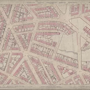
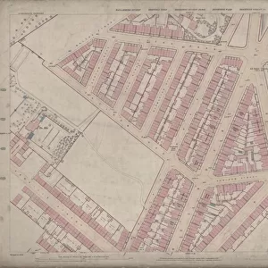
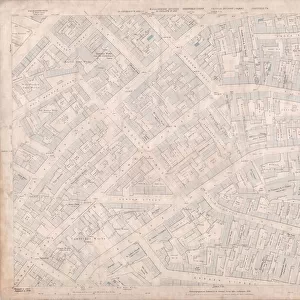
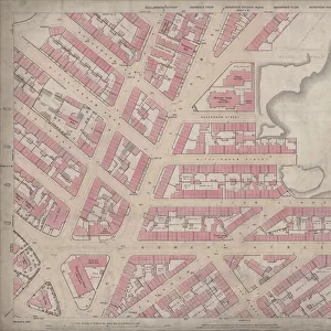
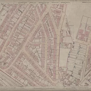
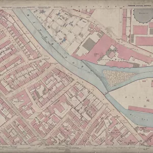
Ordnance Survey Map, Burngreave area of Sheffield, 1889 (Yorkshire sheet number 294. 4. 17)
")
![]()
Wall Art and Photo Gifts from Sheffield City Archives
Ordnance Survey Map, Burngreave area of Sheffield, 1889 (Yorkshire sheet number 294. 4. 17)
This map features
Top left: Minna Road, Burngreave Road, Melrose Road, Fox Street, Pilgrim Street, Melrose Villas, [Burngreave Road Wesleyan Chapel] Methodist Chapel (at junction of Burngreave Road and Christ Church Road), Brook Villas, Wood Bank, Lea Wood, old quarry, Christ Church Road, Hope Villa, Malton Villas, Burngreave Cemetery.
Top right: Melrose Road, Melrose Villas, Burngreave Street, Sun Street, Mortuary Chapel (C of E), Mortuary Chapel (Non-conformist), Burngreave Cemetery.
Bottom left: Minna Road, Burngreave Road, Fox Street, Rock Street, Rising Street, Carlton House, Rock End, Fox Street, Cranworth Place, Brotherton Street, Nottingham Street, Cranworth Road, Claremont Villa, Manor View, Elm Villas, Thorne Place, Thornton Place, Bank View, Carlton Place, Baines Place, Rock Rise, Ash Mount, Elm Cottage, Rock Cottage, Wood View, Woodview House, Clyde Place, Brotherton Place, Rock Terrace, Beech View, Augusta Villas, [Nottingham Cliff?] Recreation Ground.
Bottom right: Burngreave Street, Hebden Villas, Hebden House, Sun Street, Burngreave Bank, Danville Terrace, Danville Street.
Dimensions of original 77 x 102 cm.
Scale 10.56 feet : 1 mile [1:500].
From an original at Sheffield Libraries: q00040 (sheet number 294.4.17)
Sheffield City Archives and Local Studies Library has an unrivalled collection of images of Sheffield, England
Media ID 24115397
© Sheffield City Council - All Rights Reserved
Burngreave Old Map Os Maps Sheffield Yorkshire
FEATURES IN THESE COLLECTIONS
> Animals
> Insects
> Hemiptera
> Beech Scale
> Europe
> United Kingdom
> England
> Yorkshire
> Brotherton
> Europe
> United Kingdom
> England
> Yorkshire
> Carlton
> Europe
> United Kingdom
> England
> Yorkshire
> Hebden
> Europe
> United Kingdom
> England
> Yorkshire
> Malton
> Europe
> United Kingdom
> England
> Yorkshire
> Sheffield
> Europe
> United Kingdom
> England
> Yorkshire
> Street
> Europe
> United Kingdom
> England
> Yorkshire
> Thorne
> Europe
> United Kingdom
> England
> Yorkshire
> Thornes
> Europe
> United Kingdom
> England
> Yorkshire
> Thornton
> Sheffield City Archives
> Maps and Plans
> Sheffield OS maps
EDITORS COMMENTS
This print showcases an Ordnance Survey Map of the Burngreave area in Sheffield, dating back to 1889. The map, identified as Yorkshire sheet number 294.4.17, offers a fascinating glimpse into the past and provides valuable insights into the historical landscape of this vibrant city. The top left section of the map reveals intriguing landmarks such as Minna Road, Burngreave Road, Melrose Road, Fox Street, and Pilgrim Street. Notably featured is the Burngreave Road Wesleyan Chapel Methodist Chapel located at the junction of Burngreave Road and Christ Church Road. Other notable points include Brook Villas, Wood Bank, Lea Wood, an old quarry site, Christ Church Road itself along with Hope Villa and Malton Villas. Moving to the top right corner unveils Melrose Road once again alongside Melrose Villas and Burngreave Street. Additionally highlighted are Sun Street and two Mortuary Chapels - one belonging to C of E (Church of England) while another designated for Non-conformists - all within proximity to Burngreave Cemetery. The bottom left portion encompasses various streets like Minna Road, Fox Street, Rock Street as well as Rising Street leading towards Carlton House and Rock End. Cranworth Place intersects with Brotherton Street before reaching Nottingham Street and Cranworth road further down. Numerous residences including Claremont Villa can be spotted along Manor View while Elm Villas grace Thorne Place. Finally exploring the bottom right quadrant exposes more details about Burngreave's layout featuring Hebden Villas near Sun street adjacent to Danville Terrace on Burngreave Bank. Measuring a substantial 77 x 102 cm in its original form with a scale ratio of 10.56 feet:1 mile (1:500), this remarkable piece originates from Sheffield Libraries' collection under reference q00040 (sheet number 294.4.17). It offers an invaluable resource for historical research and a captivating visual representation of Sheffield's past
MADE IN THE USA
Safe Shipping with 30 Day Money Back Guarantee
FREE PERSONALISATION*
We are proud to offer a range of customisation features including Personalised Captions, Color Filters and Picture Zoom Tools
SECURE PAYMENTS
We happily accept a wide range of payment options so you can pay for the things you need in the way that is most convenient for you
* Options may vary by product and licensing agreement. Zoomed Pictures can be adjusted in the Cart.