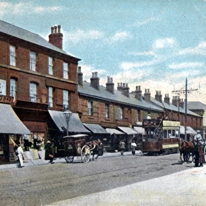
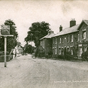
Home > Europe > United Kingdom > England > Norfolk > Harleston
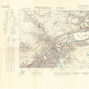
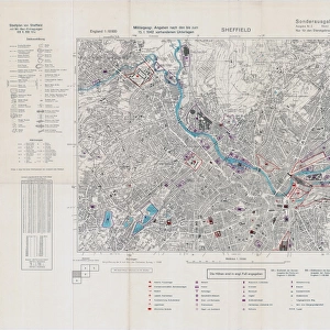
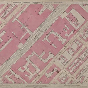
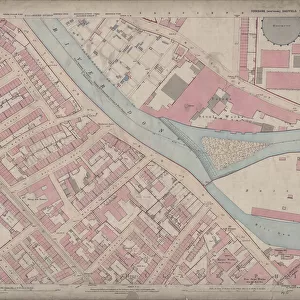
Ordnance Survey Map, Carlisle Street East and Savile Street East area, Sheffield, 1889 (Yorkshire sheet No. 294. 4. 24)
")
![]()
Wall Art and Photo Gifts from Sheffield City Archives
Ordnance Survey Map, Carlisle Street East and Savile Street East area, Sheffield, 1889 (Yorkshire sheet No. 294. 4. 24)
This map features:
Top left: Bessemer Steel Works [Bessemer and Co. Ltd], Carlisle Street East; Midland Railway Goods Line; Atlas Steel and Iron Works [John Brown and Co], Carlisle Street East; Harleston Iron Works [?Moorwoods Ltd], Harleston Street / Forncett Street; Durham Foundry, Harleston Street; Hallcar Gannister and Mortar Mills, Carlisle Street East.
Top right: Atlas Steel and Iron Works [John Brown and Co], Carlisle Street East; Midland Railway Goods Line; Norfolk Steel and Iron Works [Thomas Firth and Sons Ltd], Savile Street East; President Steel Works [Moses Eadon and Sons Limited]; Greystock Street; and Lord Nelson Inn, Norroy Street.
Bottom left: Carlisle Street East; Bessemer Steel Works [Bessemer and Co. Ltd], Carlisle Street East; Midland Railway Goods Line; Norfolk Steel and Iron Works [Thomas Firth and Sons Ltd], Savile Street East; Tramway; Carlisle Works [Kayser Ellison and Co. Ltd]; Wire Works; Etna Works [Spear and Jackson, Aetna Works, Savile Street East]; Cyclops Works [Charles Cammell and Co. Ltd, Savile Street]; and Sutherland Street.
Bottom right: Norfolk Steel and Iron Works [Thomas Firth and Sons Ltd], Savile Street East; Atlas Steel and Iron Works [John Brown and Co], Carlisle Street East; Savile Street East; Tramway; Greystock Street; Mortar Works; Queens Hotel Public House, Savile Street East; Windsor Street; Travelling crane; Norfolk Works (Edge Tools); Fersfield Street; Midland Railway; Norroy Bridge; School (Boys and Girls); Playground; Wesleyan Methodist Chapel, Princess Street; Royds Foundry; Corby Street; and Princess Street.
Scale 10.56 feet : 1 mile [1:500].
From an original at Sheffield Libraries: q00046 (sheet No. 294.4.24)
Sheffield City Archives and Local Studies Library has an unrivalled collection of images of Sheffield, England
Media ID 24293933
© Sheffield City Council - All Rights Reserved
Attercliffe Grimesthorpe Old Map Os Map Sheffield Yorkshire Steelworks
FEATURES IN THESE COLLECTIONS
> Arts
> Artists
> B
> John Brown
> Europe
> United Kingdom
> England
> Durham
> Durham
> Europe
> United Kingdom
> England
> Norfolk
> Fersfield
> Europe
> United Kingdom
> England
> Norfolk
> Harleston
> Europe
> United Kingdom
> England
> Yorkshire
> Attercliffe
> Europe
> United Kingdom
> England
> Yorkshire
> Sheffield
> Europe
> United Kingdom
> England
> Yorkshire
> Street
> Europe
> United Kingdom
> Scotland
> Sutherland
> Maps and Charts
> Related Images
> Popular Themes
> Lord Nelson
> Sheffield City Archives
> Maps and Plans
> Sheffield OS maps
EDITORS COMMENTS
This print showcases an Ordnance Survey Map of the Carlisle Street East and Savile Street East area in Sheffield, dating back to 1889. The map, labeled as Yorkshire sheet No. 294.4.24, provides a fascinating glimpse into the industrial landscape of the time. In the top left corner, we can spot prominent landmarks such as Bessemer Steel Works by Bessemer and Co. Ltd. , Atlas Steel and Iron Works operated by John Brown and Co. , Harleston Iron Works possibly owned by Moorwoods Ltd. , Durham Foundry on Harleston Street, and Hallcar Gannister and Mortar Mills on Carlisle Street East. Moving to the top right section of the map, we discover more significant sites including Norfolk Steel and Iron Works managed by Thomas Firth and Sons Ltd. , President Steel Works belonging to Moses Eadon & Sons Limited, Greystock Street intersecting with Lord Nelson Inn situated on Norroy Street. The bottom left quadrant reveals additional key locations like Carlisle Street East itself along with its associated businesses such as Kayser Ellison & Co. 's Carlisle Works, Wire Works nearby Tramway lines leading towards Etna Works (Spear & Jackson) on Savile Street East), Cyclops Works run by Charles Cammell & Co. Ltd. , Sutherland Street among others. Lastly, at the bottom right corner lies Norfolk Steel and Iron works once again alongside Atlas Steel and Iron works in close proximity to Savile street east while featuring notable spots like Queens Hotel Public House on Windsor street near Mortar works; Wesleyan Methodist Chapel located on Princess street; Midland Railway crossing Norroy Bridge; Boys'and Girls' School with a playground nearby; Royds Foundry; Corby street leading towards Princess street. With a scale of 10.56 feet:1 mile [1:500], this historical document offers valuable insights into Sheffield's industrial past. This print is sourced from Sheffield Libraries' original document q000
MADE IN THE USA
Safe Shipping with 30 Day Money Back Guarantee
FREE PERSONALISATION*
We are proud to offer a range of customisation features including Personalised Captions, Color Filters and Picture Zoom Tools
SECURE PAYMENTS
We happily accept a wide range of payment options so you can pay for the things you need in the way that is most convenient for you
* Options may vary by product and licensing agreement. Zoomed Pictures can be adjusted in the Cart.