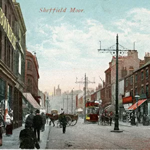
Home > Europe > United Kingdom > England > Yorkshire > Sheffield
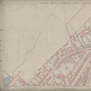
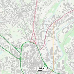
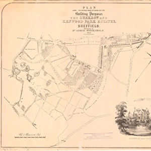
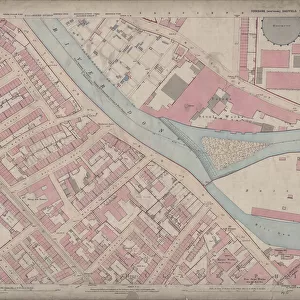
Ordnance Survey Map, Carwood Road / Petre Street area of Sheffield, 1889 (Yorkshire sheet number 294. 4. 14)
")
![]()
Wall Art and Photo Gifts from Sheffield City Archives
Ordnance Survey Map, Carwood Road / Petre Street area of Sheffield, 1889 (Yorkshire sheet number 294. 4. 14)
his map features:
Top left: Meadow Head [?house], Carwood Lane. Added in pencil Carwood Terrace.
Top right: Recreation Ground.
Bottom left: Carwood Lane, Hallcar Terrace, Carwood Crescent (a row of terrace houses), Housleys Row, Petre Street, Carwood Lane, Jamaica Street, Canada Street, Mission Hall (Gospel Union) [Whites directory of 1896 lists Salvation Army Rooms in Canada Street]; added in pencil Carwood Crescent.
Bottom right: Old quarry, Carlisle Street East.
Dimensions of original: 77 x 102 cm.
Scale 10.56 feet : 1 mile [1:500].
From an original at Sheffield Libraries: q00038 (sheet number 294.4.14)
Sheffield City Archives and Local Studies Library has an unrivalled collection of images of Sheffield, England
Media ID 24104305
© Sheffield City Council - All Rights Reserved
FEATURES IN THESE COLLECTIONS
> Animals
> Insects
> Hemiptera
> Hall Scale
> Europe
> United Kingdom
> England
> Yorkshire
> Sheffield
> Europe
> United Kingdom
> England
> Yorkshire
> Street
> Maps and Charts
> Related Images
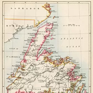
> North America
> Canada
> Maps
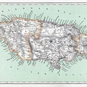
> North America
> Jamaica
> Maps
> Sheffield City Archives
> Maps and Plans
> Sheffield OS maps
EDITORS COMMENTS
This print showcases an Ordnance Survey Map of the Carwood Road and Petre Street area in Sheffield, dating back to 1889. The map, with Yorkshire sheet number 294.4.14, offers a fascinating glimpse into the city's past. In the top left corner of the map, we can see Meadow Head, possibly a house or landmark at that time. Adjacent to it is Carwood Lane and a noteworthy addition made in pencil: Carwood Terrace. Moving to the top right section, our eyes are drawn to a Recreation Ground where locals likely gathered for leisurely activities. The bottom left portion reveals several streets and residential areas such as Hallcar Terrace, Housleys Row, Petre Street, Jamaica Street, and Canada Street. Notably mentioned is a Mission Hall (Gospel Union) which served as an important religious center during that era; interestingly enough Whites directory of 1896 lists Salvation Army Rooms on Canada Street. Finally, in the bottom right corner lies an old quarry situated near Carlisle Street East – evidence of Sheffield's industrial heritage. Measuring 77 x 102 cm in its original form and featuring a scale ratio of 10.56 feet : 1 mile (1:500), this historical document provides invaluable insights into Sheffield's urban landscape over a century ago. Courtesy of Sheffield Libraries' archives under reference q00038 (sheet number 294.4.14), this remarkable piece transports us back in time to explore the
MADE IN THE USA
Safe Shipping with 30 Day Money Back Guarantee
FREE PERSONALISATION*
We are proud to offer a range of customisation features including Personalised Captions, Color Filters and Picture Zoom Tools
SECURE PAYMENTS
We happily accept a wide range of payment options so you can pay for the things you need in the way that is most convenient for you
* Options may vary by product and licensing agreement. Zoomed Pictures can be adjusted in the Cart.