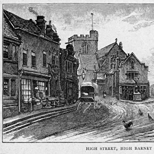
Home > Europe > United Kingdom > England > London > Boroughs > Barnet
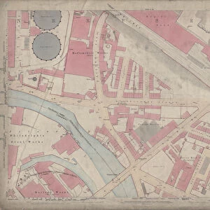
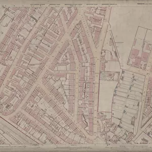
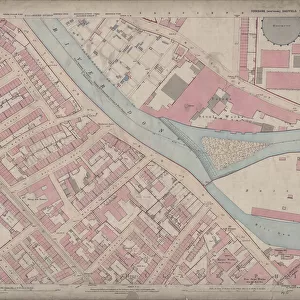
Ordnance Survey Map, Sheffield, Bates Street area, Crookes, Sheffield, 1889 (Yorkshire sheet 294. 7. 7)
")
![]()
Wall Art and Photo Gifts from Sheffield City Archives
Ordnance Survey Map, Sheffield, Bates Street area, Crookes, Sheffield, 1889 (Yorkshire sheet 294. 7. 7)
This map features:
Top left: Slinn Street, Old quarry, Townend Street, Mona Road, Bates Street, Heavy Gate Road, Sunnyside, Olivet Mount, Grasmere Villa, Belvoir House.
Top right: Heavy Gate Road, Rose Cottage, Birkendale Cottage, Matlock Road, Howard Road, Unnamed Road [later called Birkendale], Unnamed Road [later called Upperthorpe], St Josephs Home (Industrial School for Catholic Girls), [St Josephs Home] Chapel, [St Josephs Roman Catholic] School (Boys and Girls), Howard Hill, The Firs, Howard Villa, Hopefield House, Melbourne House, Poplar Villas, Terrace Villa, Clarendon Villa, Maude Villa, Fern Place, Ivy Ville, Springvale Road, Springvale Villa, Exeter House, Barnet Villa, Gloddaeth Leigh, Beech House Lodge, Sunnyside, Gordon Bank, Hardwick House.
Bottom left: Townend Street, Mona Road, Bates Street, Holly House, Glenmay Place, Springvale Terrace, Laughton View, Tudor Cottage, Prospect Cottage, Mona Villa, Tunbridge Villa, Springvale Road, Bowling green, Melbourne Road, Hands Lane, Steel Bank.
Bottom right: Bates Street, Springvale Road, Sydney Road, Bowling Green, Gloddaeth Leigh, The Hollies, Melbourne Villas, Spring Vale, Springvale Hotel Public House, Plantation Villa, Ash Bank, Abney View, Thorne Ville, Moor End, Commonside, Kaye Place, Barber Place, Barber Road, Barber Nook Cottage, West View, Thorne Lea, Moorend Terrace.
Dimensions of original: 77 x 102 cm.
Scale 10.56 feet : 1 mile [1:500].
From an original at Sheffield Libraries: q00051 (sheet No. 294.7.7)
Sheffield City Archives and Local Studies Library has an unrivalled collection of images of Sheffield, England
Media ID 24576215
© Sheffield City Council - All Rights Reserved
Crookes Os Map Sheffield Yorkshire
FEATURES IN THESE COLLECTIONS
> Animals
> Insects
> Hemiptera
> Beech Scale
> Animals
> Insects
> Hemiptera
> Fern Scale
> Animals
> Insects
> Hemiptera
> Green Scale
> Animals
> Insects
> Hemiptera
> Holly Scale
> Animals
> Insects
> Hemiptera
> Rose Scale
> Europe
> United Kingdom
> England
> London
> Boroughs
> Barnet
> Europe
> United Kingdom
> England
> Yorkshire
> Bowling
> Europe
> United Kingdom
> England
> Yorkshire
> Crookes
> Europe
> United Kingdom
> England
> Yorkshire
> Moorends
> Sheffield City Archives
> Maps and Plans
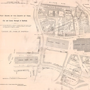
> Sheffield OS maps
EDITORS COMMENTS
This print showcases an Ordnance Survey Map of the Bates Street area in Crookes, Sheffield from 1889. The map, known as Yorkshire sheet 294.7.7, provides a detailed depiction of the region during that time. In the top left corner of the map, we can observe various landmarks such as Slinn Street, Old quarry, Townend Street, Mona Road, Bates Street, Heavy Gate Road, Sunnyside, Olivet Mount and several beautiful houses including Grasmere Villa and Belvoir House. Moving to the top right section of the map reveals more intriguing locations like Rose Cottage and Birkendale Cottage along Heavy Gate Road. Additionally featured are St Josephs Home (Industrial School for Catholic Girls), its chapel and school buildings for boys and girls. Notable residences in this area include Howard Hill, The Firs, Howard Villa among others. The bottom left portion highlights significant places such as Holly House on Bates Street along with Glenmay Place and Springvale Terrace nearby. Further down on this side lies Melbourne Road with Hands Lane intersecting it. Lastly but not least important is the bottom right quadrant which encompasses Sydney Road leading to Bowling Green where Spring Vale Hotel Public House stands proudly amidst other structures like Gloddaeth Leigh and Moor End. Measuring at 77 x 102 cm with a scale ratio of 10.56 feet : 1 mile [1:500], this original piece holds historical value preserved by Sheffield Libraries under reference q00051 (sheet No. 294.7.7). It offers a fascinating glimpse into Sheffield's past while highlighting notable streetscapes and architectural gems within the Bates Street area in Crookes during Victorian times.
MADE IN THE USA
Safe Shipping with 30 Day Money Back Guarantee
FREE PERSONALISATION*
We are proud to offer a range of customisation features including Personalised Captions, Color Filters and Picture Zoom Tools
SECURE PAYMENTS
We happily accept a wide range of payment options so you can pay for the things you need in the way that is most convenient for you
* Options may vary by product and licensing agreement. Zoomed Pictures can be adjusted in the Cart.

![A map of the lands at and near Crooks [Crookes] part in Ecclesall and part in Nether Hallam, 1790](/sq/716/map-lands-near-crooks-crookes-ecclesall-nether-14049486.jpg.webp)