Home > Europe > United Kingdom > England > Yorkshire > Walkley
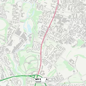
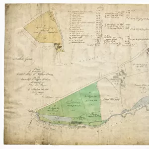
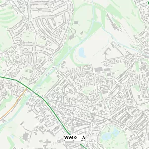
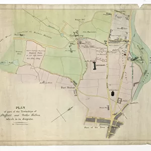
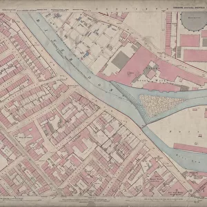
Ordnance Survey Map, Sheffield, Blake Street area, Netherthorpe, Sheffield, 1889 (Yorkshire sheet No. 294. 7. 3)
")
![]()
Wall Art and Photo Gifts from Sheffield City Archives
Ordnance Survey Map, Sheffield, Blake Street area, Netherthorpe, Sheffield, 1889 (Yorkshire sheet No. 294. 7. 3)
This map features:
Top left: Daniel Hill Street, Elton Street, Harworth Street, Harworth Road, Walkley Street, Duncombe Street, Fulton Road, Blake Street Hotel Public House [Blake Hotel].
Top right: Daniel Hill Street, Sheard Road, Fox Road, Harold Street, Otley Street, Blake Street, White Cottages, Clumber Villas, Fern Villas, Edley Villas, Old Quarry, Providence Cottage, Daniel Hill.
Bottom left: Fulton Road, Fulton Road Wesleyan Methodist Chapel, Upperthorpe, Unnamed street [later called Birkendale], Unnamed streets (Later called Birkendale Road / Birkendale View), Elm Cottage, Birkendale House, Laurel Cottage, Eagle House, Alma House, Rustling Villa, Ida Villa, Ash Villa, Holyrood House, Ashley Villa, Hawthorne Mount, Primrose Villa, Montville, Shireoakes Villa, Scotland Villa, Fern Bank, Ormside, Rose Villa, Vine Cottage.
Bottom right: Upperthorpe, unnamed street (Later called Birkendale Road), Unnamed street (Later called Birkendale), Rose Villa, Vine Cottage, Blake Street, White Cottages, Clumber Villas, Mona House, Blake House, Fern Villas, Canton Place, Bell Monte, St. Philips Vicarage, Spring Villa, Crowley House, East View, Blake Terrace, Grove House, Birch Terrace, Victoria Villas, Blake Grove Road, Birch House, Hollis Terrace, Portland Crescent, Upperthorpe, Blake House Terrace, Ada Street, old quarry.
Dimensions of original: 77 x 102 cm.
Scale 10.56 feet : 1 mile [1:500].
From an original at Sheffield Libraries: q00049 (sheet No. 294.7.3)
Sheffield City Archives and Local Studies Library has an unrivalled collection of images of Sheffield, England
Media ID 24576211
© Sheffield City Council - All Rights Reserved
Old Map Os Map Sheffield Yorkshire
FEATURES IN THESE COLLECTIONS
> Animals
> Insects
> Hemiptera
> Fern Scale
> Animals
> Insects
> Hemiptera
> Rose Scale
> Europe
> United Kingdom
> England
> Yorkshire
> Otley
> Europe
> United Kingdom
> England
> Yorkshire
> Sheffield
> Europe
> United Kingdom
> England
> Yorkshire
> Street
> Europe
> United Kingdom
> England
> Yorkshire
> Walkley
> Europe
> United Kingdom
> Scotland
> Maps
> Sheffield City Archives
> Maps and Plans
> Sheffield OS maps
EDITORS COMMENTS
This vintage Ordnance Survey map from 1889 showcases the Blake Street area in Netherthorpe, Sheffield. The detailed print provides a fascinating glimpse into the city's history and urban development during that era. The top left section of the map highlights notable streets such as Daniel Hill Street, Elton Street, Harworth Street, and Walkley Street. It also features landmarks like the Blake Hotel (formerly known as Blake Street Hotel), adding to its historical significance. Moving to the top right corner, we see Daniel Hill Street again along with Sheard Road and Fox Road. Other points of interest include White Cottages, Clumber Villas, Fern Villas, and Old Quarry. This part of Sheffield was evidently home to various residential areas and cottages. As we shift our focus to the bottom left portion of the map, Fulton Road takes center stage alongside Fulton Road Wesleyan Methodist Chapel. Upperthorpe is also highlighted here along with an unnamed street later called Birkendale. Notable houses such as Rustling Villa and Hawthorne Mount are marked on this side. Lastly, in the bottom right corner lies Upperthorpe once more along with Vine Cottage and Rose Villa. Landmarks like St. Philips Vicarage add character to this neighborhood while streets like Ada Street provide insight into local infrastructure. Measuring at 77 x 102 cm in its original form with a scale of 10.56 feet : 1 mile [1:500], this piece represents a valuable archival item preserved by Sheffield Libraries for future generations to explore their city's past.
MADE IN THE USA
Safe Shipping with 30 Day Money Back Guarantee
FREE PERSONALISATION*
We are proud to offer a range of customisation features including Personalised Captions, Color Filters and Picture Zoom Tools
SECURE PAYMENTS
We happily accept a wide range of payment options so you can pay for the things you need in the way that is most convenient for you
* Options may vary by product and licensing agreement. Zoomed Pictures can be adjusted in the Cart.