Home > Europe > United Kingdom > England > Yorkshire > Whitley
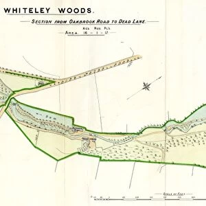
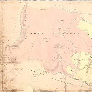
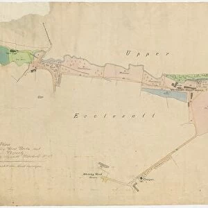
Plan showing the Porter Brook, Whiteley Woods, Sheffield, c. 1826

![]()
Wall Art and Photo Gifts from Sheffield City Archives
Plan showing the Porter Brook, Whiteley Woods, Sheffield, c. 1826
Shows the Porter Brook from Forge Dam across to Hangingwater Road.
From an original at Sheffield Libraries: arc03974
Sheffield City Archives and Local Studies Library has an unrivalled collection of images of Sheffield, England
Media ID 20653805
© Sheffield City Council - All Rights Reserved
FEATURES IN THESE COLLECTIONS
> Europe
> United Kingdom
> England
> Yorkshire
> Sheffield
> Europe
> United Kingdom
> England
> Yorkshire
> Whitley
> Maps and Charts
> Related Images
> Sheffield City Archives
> Maps and Plans
> Maps of Sheffield
EDITORS COMMENTS
This print transports us back to the picturesque landscape of Whiteley Woods in Sheffield, Yorkshire, circa 1826. The image showcases a meticulously detailed plan that reveals the course of the enchanting Porter Brook as it gracefully meanders from Forge Dam across to Hangingwater Road. The scene is imbued with an undeniable sense of tranquility and natural beauty. The crystal-clear waters of the Porter Brook glisten under the gentle sunlight, reflecting the surrounding lush greenery and creating a mesmerizing spectacle for all who behold it. This historical document, preserved by Sheffield Libraries at their esteemed City Archives, offers a unique glimpse into the past and allows us to appreciate how nature has evolved over time. It serves as a testament to our ancestors' appreciation for preserving such idyllic landscapes amidst rapid industrialization. As we immerse ourselves in this visual masterpiece, let us take a moment to imagine strolling along its banks or perhaps even dipping our toes into its cool waters on a warm summer's day. This photograph reminds us of the intrinsic value nature holds in our lives and encourages us to cherish and protect these precious ecosystems for future generations
MADE IN THE USA
Safe Shipping with 30 Day Money Back Guarantee
FREE PERSONALISATION*
We are proud to offer a range of customisation features including Personalised Captions, Color Filters and Picture Zoom Tools
SECURE PAYMENTS
We happily accept a wide range of payment options so you can pay for the things you need in the way that is most convenient for you
* Options may vary by product and licensing agreement. Zoomed Pictures can be adjusted in the Cart.