Home > Europe > United Kingdom > England > Manchester > Manchester
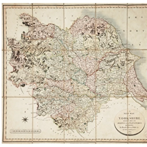
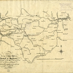
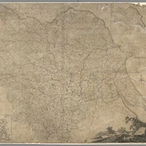
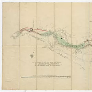
Sheffield, Ashton under Lyme and Manchester Railway, 1846

![]()
Wall Art and Photo Gifts from Sheffield City Archives
Sheffield, Ashton under Lyme and Manchester Railway, 1846
Alfred S. Jee, engineer.Scale 1/2 inch : 1 mile.Original dimensions 185 x 80 cm.Original at Sheffield City Archives: SY205/1
Sheffield City Archives and Local Studies Library has an unrivalled collection of images of Sheffield, England
Media ID 14046475
© Sheffield City Council
Maps Plans Rail Railway Sheffield Transport Manchester
FEATURES IN THESE COLLECTIONS
> Arts
> Artists
> D
> Alfred
> Related Images
> Europe
> United Kingdom
> England
> Manchester
> Manchester
> Maps and Charts
> Related Images
> Sheffield City Archives
> Maps and Plans
EDITORS COMMENTS
This print takes us back in time to the year 1846, when the Sheffield, Ashton under Lyme and Manchester Railway was a bustling hub of activity. The image showcases the remarkable engineering prowess of Alfred S. Jee, who played a pivotal role in bringing this railway system to life. With a scale of 1/2 inch to 1 mile, this detailed print offers an intricate view of the railway's original dimensions, spanning an impressive 185 x 80 cm. It is truly awe-inspiring to witness how such vast stretches of land were meticulously planned and transformed into efficient transportation routes. Preserved at Sheffield City Archives under reference SY205/1, this historic artifact serves as a testament to the importance placed on documenting our rich industrial heritage. As we gaze upon this photograph, we are transported back in time and can almost hear the rhythmic chugging of steam engines and feel the excitement that must have permeated these tracks. While it is important not to mention any commercial use associated with this photo print, its significance lies in its ability to educate and inspire generations about our past achievements in rail transport. This visual representation allows us to appreciate both the ingenuity behind constructing such railways and their vital role in connecting communities during that era. In conclusion, this extraordinary piece from Sheffield City Archives provides us with a glimpse into history - reminding us how far we've come while honoring those visionary engineers who shaped our world through their groundbreaking work on railways like these.
MADE IN THE USA
Safe Shipping with 30 Day Money Back Guarantee
FREE PERSONALISATION*
We are proud to offer a range of customisation features including Personalised Captions, Color Filters and Picture Zoom Tools
SECURE PAYMENTS
We happily accept a wide range of payment options so you can pay for the things you need in the way that is most convenient for you
* Options may vary by product and licensing agreement. Zoomed Pictures can be adjusted in the Cart.
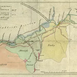
![A map of the lands near Attercliffe and Darnall, [?1820s]](/sq/716/map-lands-near-attercliffe-darnall-1820s-18396317.jpg.webp)