Home > Animals > Insects > Hemiptera > Beech Scale
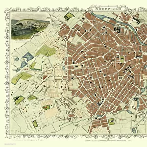
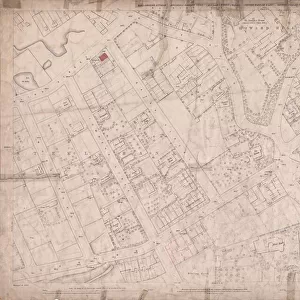
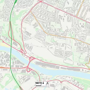
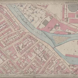
Ordnance Survey Map, Broomhill area of Sheffield, 1889 (Yorkshire sheet 294. 7. 23)
")
![]()
Wall Art and Photo Gifts from Sheffield City Archives
Ordnance Survey Map, Broomhill area of Sheffield, 1889 (Yorkshire sheet 294. 7. 23)
This map features:
Top left: Whitham Road, Wellesley Road, Damer Street, Claremont Crescent, Tree Root Walk, Northumberland Road, Durham House, Palmerston Road, Godfrey Dam Lodge, Westcliffe, Beech Holme, Pentonville, Beechfield, Astley House, Thorne Lege, Hillside, Lawn Cottage, Thornecliffe, Norfolk House, Claremont Villa, Ivy Cottage, Albert House, Myrlewood, The Hollies, Oakburn, Cliftonville, Burnham Lodge, West Lodge, Mushroom Bank, and Westbourne House.
Top right: Northumberland Road, Durham House, Palmerston Road, Durham Road, Clarkson Street, West Bank Place, Glossop Road, Glossop Road Baptist Chapel and Sunday School, Shearwood Road, Wilkinson Street, Glossop Lane, Children's Hospital, Nelson Place, Westville House, Nelson Terrace, Devonshire Place, Portmore Place, Durham Place, West Bank, Clarkson Place, Northumberland Place, Northumberland House, Fernley Place, Lorne House, The Dene, Durham Lane, Newstead, Pembroke Villa, Claremont Cottage, Chevin, Holly Bank, Shearwood Mount, Northumberland View, Northumberland Villa, Yarborough House, and West End Hotel Public House.
Bottom left: Tree Root Walk, Broom Cross, Beech Hill Road, Claremont Place, Stone Grove, Adelaide Place, Broombank Mount, Broombank House, Five Oaks, Valetta, Broomville House, The Brooms, Broomfield Road.
Bottom right: Tree Root Walk, Claremont Place, Adelaide Place, Glossop Road, Shearwood Road, Broomspring Lane, Gloucester Street, Dorset Street, Broomspring House, Claremont Villa, West Lawn, Egerton House, Glossop Road Post Office, Springfield Place, and Shrubland House.
Dimensions of original 77 x 102 cm.
Scale 10.56 feet : 1 mile [1:500].
From an original at Sheffield Libraries: q00074
Sheffield City Archives and Local Studies Library has an unrivalled collection of images of Sheffield, England
Media ID 32416451
© Sheffield City Council - All Rights Reserved
Broomhill Old Map Ordnance Survey Os Map Sheffield
FEATURES IN THESE COLLECTIONS
> Animals
> Insects
> Hemiptera
> Beech Scale
> Animals
> Insects
> Hemiptera
> Holly Scale
> Arts
> Artists
> W
> C.A. Wilkinson
> Europe
> United Kingdom
> England
> Dorset
> Grove
> Europe
> United Kingdom
> England
> Durham
> Durham
> Europe
> United Kingdom
> England
> Norfolk
> West End
> Europe
> United Kingdom
> England
> Northumberland
> Broomhill
> Europe
> United Kingdom
> England
> Yorkshire
> Holme
> Europe
> United Kingdom
> England
> Yorkshire
> Sheffield
> Europe
> United Kingdom
> England
> Yorkshire
> Street
> Sheffield City Archives
> Maps and Plans
> Sheffield OS maps
EDITORS COMMENTS
This print showcases an Ordnance Survey Map of the Broomhill area in Sheffield, dating back to 1889. The map, known as Yorkshire sheet 294.7.23, provides a fascinating glimpse into the past with its intricate details and historical landmarks. In the top left corner of the map, we can spot Whitham Road, Wellesley Road, and Damer Street among other notable locations such as Durham House and Claremont Crescent. Moving towards the top right section, Northumberland Road and Palmerston Road catch our attention along with Glossop Road Baptist Chapel and Sunday School. The bottom left portion reveals Tree Root Walk leading to Broom Cross while also highlighting Beech Hill Road and Adelaide Place. Lastly, in the bottom right corner of this expansive map lies Shearwood Road intersecting with Glossop Road alongside Dorset Street. Measuring at an impressive 77 x 102 cm in size, this detailed piece offers a scale of 10.56 feet : 1 mile [1:500]. It is important to note that this particular print originates from Sheffield Libraries' archives (q00074) rather than any commercial entity. Transport yourself back in time as you explore this remarkable snapshot of Sheffield's history through its streetscapes and landmarks captured over a century ago on this meticulously crafted Ordnance Survey Map.
MADE IN THE USA
Safe Shipping with 30 Day Money Back Guarantee
FREE PERSONALISATION*
We are proud to offer a range of customisation features including Personalised Captions, Color Filters and Picture Zoom Tools
SECURE PAYMENTS
We happily accept a wide range of payment options so you can pay for the things you need in the way that is most convenient for you
* Options may vary by product and licensing agreement. Zoomed Pictures can be adjusted in the Cart.