Home > Animals > Farm > Horses > Related Images
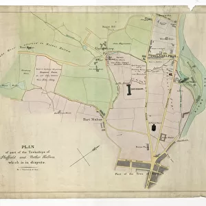
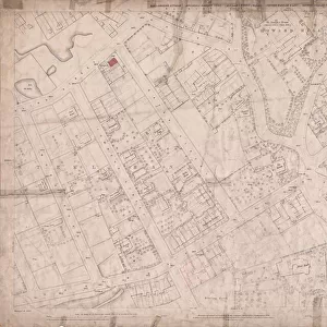
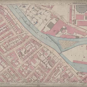
Ordnance Survey Map, City Centre, 1890 (sheet no. Yorkshire No. 294.8.16)
")
![]()
Wall Art and Photo Gifts from Sheffield City Archives
Ordnance Survey Map, City Centre, 1890 (sheet no. Yorkshire No. 294.8.16)
This map features
Top left: Campo Lane, Church Street, St. James Row Bank, Trippet Lane, Pinfold Street, Bow Street, Canterbury Hall Public House, Orchard Street, Leopold Street, Sims Croft, School Croft, Hawley Croft, Lee Croft, Townhead Street, Vicar Lane, St. James Street, St. James's Church, Golden Ball Public House, Church of England Institute, Vicarage, Burns Tavern, Townhead Street Baptist Chapel, and Temperance Hall on Townhead Street.
Top right: Campo Lane, Church Street, St. James Row, Bank, Fargate, St. Peter's Church, High Street, York Street, East Parade, Hawksworth Court, Aldine Court, Prior Court, Cutler's Hall, Fargate, George Street, Mulberry Street, Bank, White Bear Public House, Parade Chambers, [Boys] Charity School on East Parade, Bank, Sheffield Daily Telegraph Office and Printing Works, Grey Horse Public House, Old Blue Bell Public House, Shades Vault Public House, Queen Victoria Hotel Public House, White Bear Public House, Waterloo Turf Tavern, Victoria Club, Police Institute, Hartshead, Watson's Walk, Beeswing Tavern, Central Chambers, Star Hotel, Clarence Hotel, Printing Works, Athenaeum Club, Central Café, Thatched House Tavern, and York Chambers.
Bottom left: Trippet Lane, Pinfold Street, Bow Street, Canterbury Hall Public House, Orchard Street, Leopold Street, Orchard Place, Museum Hotel Public House, Firth College, Holly Street, Holly Lane, West Street Lane, West Street, Sands Paviours, Carver Lane, Barker's Pool, Exchange Gateway, Fleur-de-lis Hotel, Old Three Tuns Public House, Queen Victoria's Jubilee Monument, Central School on Orchard Lane / Leopold Street, Playground, [Willliam Hall], Alma Works (files, edge tools, etc), [John Lucas and Sons], Queen Steel Works on Orchard Lane / Holly Street, Gordon Works (horn and ivory), [J. Bright and Co.], Livingstone Works (ivory) on Holly Street, Sheffield Institute for the Blind, Red Lion Hotel, Wharncliffe Arms Public House, Smithy, Crown Inn, Pool Square, Balm Green, Water Works Office, Inland Revenue Office, and cutlery handles manufactory.
Bottom right: Exchange Gateway, Cutler's Hall, Fargate, George Street, Mulberry Street Bank, White Bear Walk, Methodist Chapel (Wesleyan) on Norfolk Street [Norfolk Street Wesleyan Chapel], Nether Chapel (congregational), Vicarage, Sunday School, St. Marie's R.C. Church, St. Marie's Presbytery, Norfolk Row, Chapel Walk, Norfolk Street, Arundel Street, Sycamore Street, Tudor Street, Upper Chapel, Montgomery Hall, Surrey Street, Bank, Albany Hotel, Derby Works (engineering), Old Red House Public House, Green Dragon Hotel, Furnival Spirit Vaults, Assembly Rooms, Theatre Royal, [John Round and Son], Tudor Works (silver, nickel silver and electro plate), Tudor Street, [C. Smith and Sons, general tinplate workers], Arundel Works (tin plate), Cutlery Works, [Joseph Rodgers and Sons Ltd.], Rodgers Grinding Wheel (cutlery), Garrick Hotel, Alliance Chambers, Sheffield Gentlemen's Club, Mulberry Tavern, and [?William Gallimore and Sons], Arundel Electro Spoon and Fork Works (on Arundel Street).
Additional information from White's General and Commercial Directory of Sheffield, 1896 / Graces Guide.
Surveyed 1889. Reprint 35/99'.
Dimensions of original: 77 x 102 cm.
Scale 10.56 feet : 1 mile [1:500].
From an original at Sheffield Libraries: q00082 (sheet no. Yorkshire No. 294.8.16)
Sheffield City Archives and Local Studies Library has an unrivalled collection of images of Sheffield, England
Media ID 33302297
© Sheffield City Council - All Rights Reserved
Old Map Ordnance Survey Os Map Sheffield
FEATURES IN THESE COLLECTIONS
> Animals
> Farm
> Horses
> Related Images
> Animals
> Insects
> Butterflies
> Smith Blue
> Animals
> Insects
> Hemiptera
> Green Scale
> Animals
> Insects
> Hemiptera
> Hall Scale
> Animals
> Insects
> Hemiptera
> Holly Scale
> Animals
> Mammals
> Horse
> Related Images
> Animals
> Reptiles
> Lizards
> Green Water Dragon
> Arts
> Artists
> L
> John Lucas
> Europe
> United Kingdom
> England
> Canterbury
> Europe
> United Kingdom
> England
> Derby
> Sheffield City Archives
> Maps and Plans
> Sheffield OS maps
EDITORS COMMENTS
This print showcases an Ordnance Survey Map of Sheffield City Centre in 1890. The map, labeled as sheet no. Yorkshire No. 294.8.16, provides a detailed depiction of the bustling city streets during this era. In the top left corner, we can observe Campo Lane, Church Street, St. James Row Bank, Trippet Lane, Pinfold Street, Bow Street, and Canterbury Hall Public House among other notable landmarks. The image also highlights various religious establishments such as St. James’s Church and Townhead Street Baptist Chapel. Moving to the top right section of the map reveals familiar names like Fargate and High Street alongside significant buildings including Cutler's Hall and Sheffield Daily Telegraph Office and Printing Works. The bottom left quadrant features Trippet Lane along with Orchard Place and Museum Hotel Public House nearby. Notable institutions such as Firth College and Sheffield Institute for the Blind are also visible on this part of the map. Lastly, in the bottom right corner lies Exchange Gateway leading to George Street while Mulberry Street intersects with White Bear Walk. This area is home to several churches like Nether Chapel (congregational) and St Marie’s R. C Church. The additional information provided indicates that this particular map was surveyed in 1889 but reprinted in '35/99'. Its original dimensions measure 77 x 102 cm with a scale ratio of 10.56 feet : 1 mile [1:500]. This specific print is sourced from Sheffield Libraries' collection (q00082). With its intricate details capturing a bygone era's urban landscape, this photograph offers viewers a fascinating glimpse into Sheffield's rich history through its meticulously mapped out city center streetscape from over a century ago.
MADE IN THE USA
Safe Shipping with 30 Day Money Back Guarantee
FREE PERSONALISATION*
We are proud to offer a range of customisation features including Personalised Captions, Color Filters and Picture Zoom Tools
SECURE PAYMENTS
We happily accept a wide range of payment options so you can pay for the things you need in the way that is most convenient for you
* Options may vary by product and licensing agreement. Zoomed Pictures can be adjusted in the Cart.