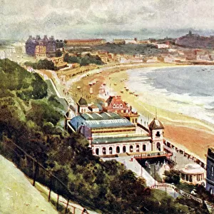
Home > Europe > United Kingdom > England > London > Boroughs > Bromley
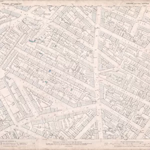
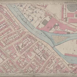
Ordnance Survey Map, Sheffield, Bramwell Street / Netherthorpe area, 1889 (Yorkshire sheet 294. 7. 14)
")
![]()
Wall Art and Photo Gifts from Sheffield City Archives
Ordnance Survey Map, Sheffield, Bramwell Street / Netherthorpe area, 1889 (Yorkshire sheet 294. 7. 14)
This map features:
Top left: Fawcett Street, Daisy Bank, Bramwell Street, Powell Street, Radford Place, Bromley Street, St. Stephens Road, Finlay Street, Mushroom Lane, Bellefield Street, Bellefield House (Girls Training School), Bellefield Street, Wentworth Street, [St Stephens National School], Finlay Street, St. Stephens Church, Bellefield Terrace.
Top right: Fawcett Street, Daisy Bank, Bramwell Street, Radford Place, Bethel Street, St Philips Road, Upper St Philips Road, Brownell Street, Daisy Walk, [John Hartley and Sons, Cutlery Manufacturers], Daisy Works, Daisy Walk, Francis Greaves and Sons, Cutlery Manufacturers], Radford Works, Radford Street, Hammond Street, Ellison Street, Netherthorpe Street, [Netherthorpe Board School], Dover Street, Jericho Street, Primitive Methodist Chapel, Jericho Street / Hoyle Street, [James and F. C. Wild], Borusssia Steel and File Works, Jericho Street, Prince of Wales Hotel Public House, [Broompark] Mission Rooms, Sunday School, Hoyle Street, Well Meadow Street, Jericho Square, Victoria Hotel Public House.
Bottom left: Powell Street, Radford Place, Latimer Street, Weston Street, [Robert Lingard], Cutlery Works, The Mount, Radford Place, Bathfield Place, Summer Street, Hope Street, Weston Street Methodist Chapel (Wesleyan Reform), Weston Terrace, [Stephen Fisher and Co. malleable iron castings], Pelham Works, Mitchell Street, Steel Works, Westgrove Square.
Bottom right: Radford Place, Latimer Street, Weston Street, Cutlery Works, St Philips Road, Upper St Philips Road, Brownell Street, Daisy Walk, Francis Greaves and Sons, Cutlery Manufacturers], Radford Works, Radford Street, Radford Street, Steam Fly Works (cutlery), Radford Street, Leicester Street, Corn Hill, Upper Allen Street, Brightmore Street, [possibly George R. Townend], Albany Works (edge tools), Radford Street, Cutlery Works, Old Brown Cow Public House, Smithy, Falcon Inn, Leicester Street, Leicester street Foundry (iron), [Brookes and Crookes], Atlantic Works (cutlery), Upper St Philips Road, Salutation Inn, Nevada Works (silver), No. 33 Leicester Street, [James Burnand and Sons, cutlery manufacturers], Leicester Works, Leicester Street, New Edward Street, The Albion Public House, Radford Lane.
Dimensions of original: 77 x 102 cm.
Scale 10.56 feet : 1 mile [1:500].
From an original at Sheffield Libraries: q00059 (sheet No. 294.7.14)
Sheffield City Archives and Local Studies Library has an unrivalled collection of images of Sheffield, England
Media ID 25801207
© Sheffield City Council - All Rights Reserved
Old Map Ordnance Survey Os Map Sheffield
FEATURES IN THESE COLLECTIONS
> Animals
> Birds
> Accipitriformes
> Accipitridae
> Brown Falcon
> Animals
> Birds
> Accipitriformes
> Falcons
> Brown Falcon
> Animals
> Insects
> Flies
> House Fly
> Europe
> United Kingdom
> England
> London
> Boroughs
> Bromley
> Europe
> United Kingdom
> England
> Yorkshire
> Crookes
> Europe
> United Kingdom
> England
> Yorkshire
> Sheffield
> Europe
> United Kingdom
> England
> Yorkshire
> Street
> Europe
> United Kingdom
> England
> Yorkshire
> Wales
> Europe
> United Kingdom
> England
> Yorkshire
> Well
> Europe
> United Kingdom
> England
> Yorkshire
> Wentworth
> Sheffield City Archives
> Maps and Plans
> Sheffield OS maps
EDITORS COMMENTS
This print showcases an Ordnance Survey Map of the Sheffield, Bramwell Street / Netherthorpe area in 1889. The map, known as Yorkshire sheet 294.7.14, provides a detailed depiction of the region during that time. The top left section of the map reveals various streets and landmarks such as Fawcett Street, Daisy Bank, Powell Street, and St. Stephens Church. It also highlights Bellefield House (Girls Training School) and St Stephens National School among other notable locations. Moving to the top right portion, we discover Fawcett Street again along with Radford Place and Bethel Street. Noteworthy establishments like John Hartley and Sons (Cutlery Manufacturers), Francis Greaves and Sons (Cutlery Manufacturers), and Jericho Street's Primitive Methodist Chapel are also featured. As we explore the bottom left quadrant of this historical map print, Powell Street catches our attention alongside Weston Terrace and Hope Street. Additionally, it showcases Stephen Fisher & Co. 's malleable iron castings at Weston Street Methodist Chapel. Lastly, in the bottom right corner lies Leicester Works on Leicester street Foundry where Brookes & Crookes operated their business alongside James Burnand & Sons' cutlery manufacturers at No. 33 Leicester street. Measuring approximately 77 x 102 cm with a scale ratio of 10.56 feet : 1 mile [1:500], this original piece from Sheffield Libraries offers an intriguing glimpse into Sheffield's past for all history enthusiasts to appreciate.
MADE IN THE USA
Safe Shipping with 30 Day Money Back Guarantee
FREE PERSONALISATION*
We are proud to offer a range of customisation features including Personalised Captions, Color Filters and Picture Zoom Tools
SECURE PAYMENTS
We happily accept a wide range of payment options so you can pay for the things you need in the way that is most convenient for you
* Options may vary by product and licensing agreement. Zoomed Pictures can be adjusted in the Cart.