Home > Europe > United Kingdom > England > Yorkshire > Darley
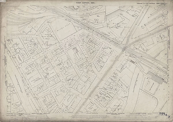
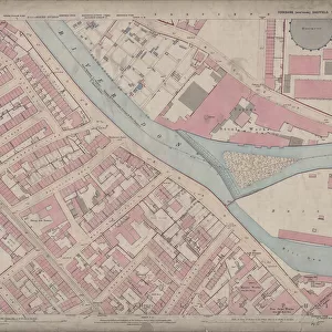
Ordnance Survey Map, The Wicker / Spital Hill, Sheffield, 1889 (Yorkshire sheet 294. 8. 7)
![]()

Wall Art and Photo Gifts from Sheffield City Archives
Ordnance Survey Map, The Wicker / Spital Hill, Sheffield, 1889 (Yorkshire sheet 294. 8. 7)
This map features:
Top left: Manchester, Sheffield and Lincolnshire Railway, Goods Shed, Brunswick Road, Andrew Street, [William Wright, mortar grinder], Nursery Steam Grinding Wheel (entrance on Brunswick Road), Spital Fields, [John Aizlewood, corn miller], Crown Corn Mills (entrance on Nursery Street), Holy Trinity School (Boys and Girls), Holy Trinity Church, Nursery Street, Nursery Lane, Johnson Street, Stanley Street, Stanley Lane, Johnson Lane, [William Briggs and Co. electroplate manufacturers], Wentworth Plate Works (entrance of Stanley Lane / Andrew Street), Albion Inn, smithy, Harlequin Inn, Manchester Hotel Public House, Bridgehouses Station, River Don, Joiner Lane, and Midland Railway Goods Line.
Top right: Manchester, Sheffield and Lincolnshire Railway, Brunswick Road, Andrew Street, Wicker Lane, Wicker, Tramway, Viaduct, Scholey Street, [Walker Eaton and Co. engineers], Wicker Iron and Engineering Works (entrance at bottom of Spital Hill), [Joshua Wigfull and Sons, corn millers and corn merchants], Star Corn Mills [on Walker Street], Walker Street, Lime kilns, Travelling cranes, smithy, Station Inn, Goods shed, Wicker Station, Spital Hill, Walker Street, [Charles Drury, iron and steel merchant], Darley Works (iron and steel) (entrance at No. 6 Savile Street), [?Henry Matthews, mahogany, timber and raff merchant, Don sawing, planning and moulding mills], Don Saw Mills (entrance on Savile Street), Lodge Inn, Savile Street, Andrew Lane, Smithy, and River Don.
Bottom left: Nursery Street, Nursery Lane, Johnson Street, Stanley Street, Stanley Lane, Johnson Lane, Holy Trinity Church, River Don, Nursery Street, [George L. Wood and Co.], Nursery Street Saw Mills, Joiner Lane, [Bethesda] Primitive Methodist Church (on Stanley Street), Sunday School, Joiner Street, Millsands, Foundry, Albion Works (on Nursery Lane), Railway Inn, [B and J, Wilcock, saw and machine knife manufacturers], Bolton Works (saws, machine knives, etc) (on Nursery Lane), Foundry, Crown and Anchor Public House, Wicker, tramway, Wicker Lane, New White Lion Inn, and Nursery Street Wire Works.
Bottom right: Manchester, Sheffield and Lincolnshire Railway, Wicker, tramway, Wicker Lane, Scholey Street, Post Office, Victoria Station, Royal Victoria Hotel, Victoria Inn, [Louis Henry Morgan, crucible manufacturer], Crucible Works (on Wicker Lane), Sheldon Yard, Sheldon Row, Willey Street, Bull Inn, Brown Cow Public House, Bull and Oak Public House, Wicker Mortar Mills (on Sheldon Row), Falstaff Inn, [Seebohm and Dieckstahl, steel convertors and refiners], Dannemora Steel Works (on Sheldon Row), Smithfield Market (with cattle pens), Victoria Station Road, Furnival Road, and [Samuel Osborn and Co. steel manufacturers], Clyde Steel and Iron Works [on Wicker].
Surveyed in 1889. Reprinted 1903.
Dimensions 77 x 102 cm.
Scale 10.56 feet : 1 mile [1:500].
From an original at Sheffield Libraries: q00078
Sheffield City Archives and Local Studies Library has an unrivalled collection of images of Sheffield, England
Media ID 32416603
© Sheffield City Council - All Rights Reserved
Old Map Ordnance Survey Os Map Sheffield
FEATURES IN THESE COLLECTIONS
> Animals
> Mammals
> Bovidae
> Cattle
> Europe
> United Kingdom
> England
> Lincolnshire
> Brigg
> Europe
> United Kingdom
> England
> Manchester
> Manchester
> Europe
> United Kingdom
> England
> Yorkshire
> Darley
> Europe
> United Kingdom
> England
> Yorkshire
> Sheffield
> Europe
> United Kingdom
> England
> Yorkshire
> Stanley
> Europe
> United Kingdom
> England
> Yorkshire
> Street
> Europe
> United Kingdom
> England
> Yorkshire
> Wentworth
> Maps and Charts
> Star Charts
> Sheffield City Archives
> Maps and Plans
> Sheffield OS maps
EDITORS COMMENTS
This print showcases an Ordnance Survey Map of The Wicker/Spital Hill in Sheffield, dating back to 1889. This detailed map, known as the Yorkshire sheet 294.8.7, offers a fascinating glimpse into the city's past. The top left section of the map reveals various landmarks and establishments that once dotted this vibrant area. From the bustling Manchester, Sheffield and Lincolnshire Railway Goods Shed to Holy Trinity School and Church, every corner tells a story. The Crown Corn Mills and Wentworth Plate Works also make their presence felt amidst the lively streets. Moving to the top right portion of the map, we discover more industrial marvels such as Wicker Iron and Engineering Works and Walker Eaton & Co. 's engineering firm. Joshua Wigfull & Sons' corn millers stand tall alongside Star Corn Mills on Walker Street while Lime kilns add a touch of historical charm. As we explore further towards the bottom left side, Nursery Street Saw Mills catch our eye along with Bethesda Primitive Methodist Church on Stanley Street. Bolton Works proudly display their saws and machine knives nearby while Crown and Anchor Public House offer respite for weary travelers. Lastly, in the bottom right quadrant lies Crucible Works by Louis Henry Morgan on Wicker Lane alongside Dannemora Steel Works on Sheldon Row. Smithfield Market stands proud with its cattle pens while Clyde Steel and Iron Works complete this industrious landscape. Surveyed in 1889 but reprinted in 1903, this remarkable piece measures 77 x 102 cm with a scale ratio of 10.56 feet:1 mile (1:500). It is sourced from an original at Sheffield Libraries (q00078) held within Sheffield City Archives - providing us with an invaluable window into Sheffield's rich history.
MADE IN THE USA
Safe Shipping with 30 Day Money Back Guarantee
FREE PERSONALISATION*
We are proud to offer a range of customisation features including Personalised Captions, Color Filters and Picture Zoom Tools
SECURE PAYMENTS
We happily accept a wide range of payment options so you can pay for the things you need in the way that is most convenient for you
* Options may vary by product and licensing agreement. Zoomed Pictures can be adjusted in the Cart.

