Home > Maps and Charts > Related Images
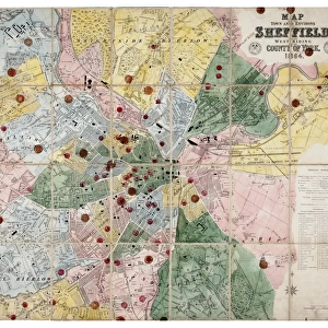
q00041

![]()
Wall Art and Photo Gifts from Sheffield City Archives
q00041
Sheffield City Archives and Local Studies Library has an unrivalled collection of images of Sheffield, England
Media ID 24121348
© Sheffield City Council - All Rights Reserved
VISUAL DESCRIPTION
The image appears to be an old map or a city plan. It shows a layout of streets and blocks with individual buildings marked, suggesting it is likely a detailed urban map from the past. The coloration indicates that certain areas might have specific zoning or types of use, as residential areas are often depicted in such maps with different colors than commercial zones. Without additional context or the ability to read any labels or legends on the map, I cannot provide specifics about the location or time period represented by this map. However, it's clear that this is a planned urban environment with structured street patterns and property divisions.
MADE IN THE USA
Safe Shipping with 30 Day Money Back Guarantee
FREE PERSONALISATION*
We are proud to offer a range of customisation features including Personalised Captions, Color Filters and Picture Zoom Tools
SECURE PAYMENTS
We happily accept a wide range of payment options so you can pay for the things you need in the way that is most convenient for you
* Options may vary by product and licensing agreement. Zoomed Pictures can be adjusted in the Cart.