Home > Sheffield City Archives > Maps and Plans
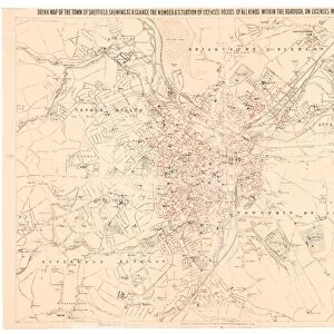
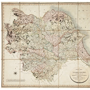
A map of the land belonging to Wortley Forges, 1746

![]()
Wall Art and Photo Gifts from Sheffield City Archives
A map of the land belonging to Wortley Forges, 1746
Marked: Three Acres, Two Acres, the High Road, Staniland Holme, Smithy Mires, River Dun [River Don], garden, Five Acres, Dusting Close, Back Meadows, Shop Croft, Nether Forge, The Damm [at Nether Forge], Hill Common, Huthwaite Common, Huthwaite Close, the Paddock, fold, the Little Croft, the Sharpefore Meadow, the Upper Forge, Spark Hill, The Damm, the Rail Piece, the Meadow, and enclosed land and common.
Surveyed by W. Fairbank.
Scale 8 chains : 1 inch.
From an original at Sheffield Libraries: arc07349
Sheffield City Archives and Local Studies Library has an unrivalled collection of images of Sheffield, England
Media ID 27963187
© Sheffield City Council - All Rights Reserved
Barnsley River Don Sheffield Wortley
FEATURES IN THESE COLLECTIONS
> Sheffield City Archives
> Maps and Plans
> Miscellaneous Maps
> Sheffield City Archives
> Maps and Plans
EDITORS COMMENTS
This print takes us back in time to the year 1746, showcasing a meticulously drawn map of the land belonging to Wortley Forges. The map is marked with various intriguing names that hint at the rich history and significance of this area. As we delve into its details, we discover familiar landmarks such as Three Acres, Two Acres, and the High Road. The map also highlights natural features like Staniland Holme and Smithy Mires, reminding us of the harmonious coexistence between man-made structures and nature during that era. The River Dun (River Don) gracefully winds its way through this landscape, adding an element of serenity amidst bustling industry. Noteworthy areas mentioned on this historical document include gardens, meadows, crofts, forges, commons, and enclosed lands. Each name carries a story waiting to be unraveled by curious minds seeking a deeper understanding of Wortley's past. Surveyed by W. Fairbank with meticulous attention to detail, this map offers invaluable insights into how our ancestors navigated their surroundings centuries ago. Preserved within Sheffield Libraries' archives under reference arc07349), it serves as a testament to the importance placed on documenting our heritage for future generations. Let us cherish this remarkable piece from Sheffield City Archives as it allows us to connect with our roots while exploring the ever-evolving landscapes shaped by human endeavors along Barnsley's Wortley Top Forge and the majestic River Don flowing through Sheffield's heartland.
MADE IN THE USA
Safe Shipping with 30 Day Money Back Guarantee
FREE PERSONALISATION*
We are proud to offer a range of customisation features including Personalised Captions, Color Filters and Picture Zoom Tools
SECURE PAYMENTS
We happily accept a wide range of payment options so you can pay for the things you need in the way that is most convenient for you
* Options may vary by product and licensing agreement. Zoomed Pictures can be adjusted in the Cart.