Home > Europe > United Kingdom > England > Yorkshire > Oldfield
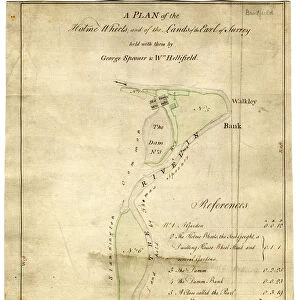
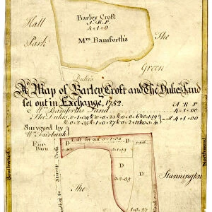
A map of Wm. Carrs Farm at Stanington [Stannington], 1747
![A map of Wm. Carrs Farm at Stanington [Stannington], 1747](/p/716/map-wm-carrs-farm-stanington-stannington-1747-19192400.jpg.webp "A map of Wm. Carrs Farm at Stanington [Stannington], 1747")
![]()
Wall Art and Photo Gifts from Sheffield City Archives
A map of Wm. Carrs Farm at Stanington [Stannington], 1747
Scale not stated.
Surveyor: William Fairbank I.
Fields north and south of Stannington Road, near the junction with Cockshutt Lane (modern Oldfield Avenue); manor house and old mote marked; perspective drawing of a farmhouse; field names given on the map and listed numerically with acreages; field boundaries brightly coloured; within a yellow border.
From an original at Sheffield Libraries: arc03001
Sheffield City Archives and Local Studies Library has an unrivalled collection of images of Sheffield, England
Media ID 19192400
© Sheffield City Council
Sheffield Stannington Yorkshire
FEATURES IN THESE COLLECTIONS
> Animals
> Insects
> Hemiptera
> Yellow Scale
> Europe
> United Kingdom
> England
> North Yorkshire
> Related Images
> Europe
> United Kingdom
> England
> South Yorkshire
> Related Images
> Europe
> United Kingdom
> England
> South Yorkshire
> Sheffield
> Europe
> United Kingdom
> England
> Yorkshire
> Oldfield
> Europe
> United Kingdom
> England
> Yorkshire
> Related Images
> Europe
> United Kingdom
> England
> Yorkshire
> Sheffield
> Europe
> United Kingdom
> England
> Yorkshire
> Stannington
> Maps and Charts
> Related Images
> Sheffield City Archives
> Maps and Plans
> Maps of Stannington
EDITORS COMMENTS
This print showcases a historical treasure - "A map of Wm. Carrs Farm at Stanington [Stannington], 1747". The intricate details and vibrant colors bring to life the rich history of this Yorkshire farm. Surveyed by the talented William Fairbank I, this map depicts the fields located north and south of Stannington Road, near Cockshutt Lane (now known as Oldfield Avenue). The manor house and its old mote are clearly marked, providing a glimpse into the grandeur of days gone by. The map also features a perspective drawing of a farmhouse, adding depth and character to the scene. Each field is labeled with its name and acreage, listed numerically for easy reference. The boundaries between these fields are beautifully highlighted in bright colors, enhancing their visibility on the map. Preserved within a striking yellow border, this print from Sheffield Libraries' archives offers an invaluable insight into the agricultural landscape of Stannington in 1747. It serves as both a historical document and an artistic masterpiece that captures the essence of rural life during that era
MADE IN THE USA
Safe Shipping with 30 Day Money Back Guarantee
FREE PERSONALISATION*
We are proud to offer a range of customisation features including Personalised Captions, Color Filters and Picture Zoom Tools
SECURE PAYMENTS
We happily accept a wide range of payment options so you can pay for the things you need in the way that is most convenient for you
* Options may vary by product and licensing agreement. Zoomed Pictures can be adjusted in the Cart.
![Maps of Several Parcels of Land proposed to be exchanged, Bradfield, [c. 1750 - 1760]](/sq/716/maps-parcels-land-proposed-exchanged-bradfield-19192402.jpg.webp)


![A survey of a parcel of Land called Platts... [Platts Farm, Ughill], 1728](/sq/716/survey-parcel-land-called-platts-19225923.jpg.webp)