Home > Sheffield City Archives > Maps and Plans > Sheffield OS maps
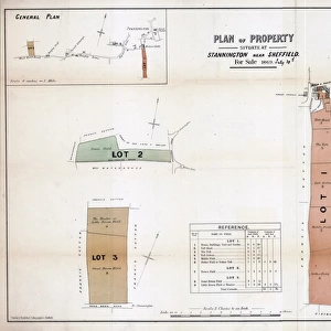
Ordnance Survey Map, Sheffield, Crookes area, 1889 (Yorkshire sheet 294. 7. 11)
")
![]()
Wall Art and Photo Gifts from Sheffield City Archives
Ordnance Survey Map, Sheffield, Crookes area, 1889 (Yorkshire sheet 294. 7. 11)
This map features
Top left: Unnamed road [later called Crookes], Unnamed road [later called Toyne Street], New Lane [Newent Lane], Long Walk, [Stannington View Road], [Duncan Road], [Springvale Road].
Top right: Unnamed road [later called Toyne Street], New Lane [Newent Lane], Springvale Road, Western Road, Cobden View Road, Rollinsford [house], [Crookes Church] Mission Room on Cobden View Road, Cobden Terrace, Old quarry.
Bottom left: Unnamed road [later called Crookes], Prospect Terrace, Crookes House, Ball Public House, Albine Terrace, Smithy (x2), Mule House Lane [Mulehouse Road], Springfield House, [Tasker Road], [Sackville Road],
Bottom right: Cobden View Road, Cobden Terrace, Cobden View Hotel Public House, St. Thomass Vicarage, Cobden Place, School Road, Bay Terrace, old quarry, Sandhurst House.
Dimensions of original: 77 x 102 cm.
Scale 10.56 feet : 1 mile [1:500].
From an original at Sheffield Libraries: q00055 (sheet No. 294.7.11)
Sheffield City Archives and Local Studies Library has an unrivalled collection of images of Sheffield, England
Media ID 25801067
© Sheffield City Council - All Rights Reserved
Old Map Os Map Sheffield Yorkshire
MADE IN THE USA
Safe Shipping with 30 Day Money Back Guarantee
FREE PERSONALISATION*
We are proud to offer a range of customisation features including Personalised Captions, Color Filters and Picture Zoom Tools
SECURE PAYMENTS
We happily accept a wide range of payment options so you can pay for the things you need in the way that is most convenient for you
* Options may vary by product and licensing agreement. Zoomed Pictures can be adjusted in the Cart.
![Maps of Several Parcels of Land proposed to be exchanged, Bradfield, [c. 1750 - 1760]](/sq/716/maps-parcels-land-proposed-exchanged-bradfield-19192402.jpg.webp)