Home > Asia > China > Maps
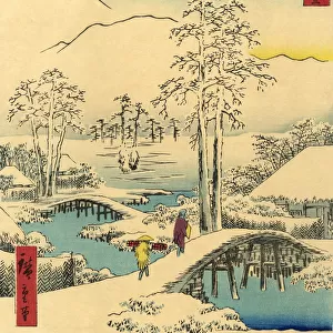
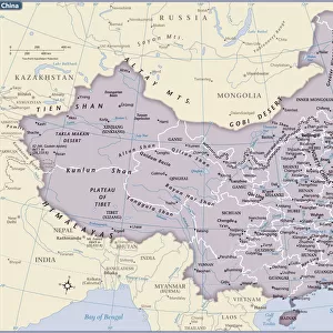
Chinese map of the world dated 1763, claiming to be a reproduction of a 1418 map of Zheng He s

![]()
Wall Art and Photo Gifts from Universal Images Group (UIG)
Chinese map of the world dated 1763, claiming to be a reproduction of a 1418 map of Zheng He s
Chinese map of the world dated 1763, claiming to be a reproduction of a 1418 map of Zheng Hes (1371-1433) voyages and to prove that Zheng He sailed both to Australia and the Americas. Many think the map is more likely to be based on 18th century European maps. Discovered by Lui Gang in 2005
Universal Images Group (UIG) manages distribution for many leading specialist agencies worldwide
Media ID 9756845
© Universal History Archive/Universal Images Group
15th 1763 18th 18th Century 2005 Americas Australia Based Century Chinese Dated Discovered Eighteenth Century European Fifteenth Gang Maps Reproduction Sailed Voyages 1418 Claiming Prove Zheng
FEATURES IN THESE COLLECTIONS
> Asia
> China
> Related Images
> Maps and Charts
> Related Images
> Maps and Charts
> World
> Oceania
> Australia
> Related Images
> Universal Images Group (UIG)
> History
EDITORS COMMENTS
This print showcases a Chinese map of the world dated 1763, which claims to be a reproduction of a remarkable 1418 map attributed to Zheng He. The renowned Chinese explorer's voyages are said to have reached far-flung destinations such as Australia and the Americas during the early 15th century. However, controversy surrounds this map's authenticity, with many scholars suggesting it is more likely based on European maps from the 18th century. Discovered by Lui Gang in 2005, this fascinating cartographic piece has ignited debates among historians and geographers alike. Its intricate details and depictions offer glimpses into ancient maritime exploration and discovery. While some argue that it provides evidence of Zheng He's extensive travels beyond what was previously believed possible for his time, others remain skeptical about its origins. The delicate brushstrokes and vibrant colors exhibited in this print highlight the artistry involved in creating such historical maps. Whether an accurate representation or not, this artifact serves as a testament to humanity's enduring curiosity about our world and its uncharted territories. As we gaze upon this intriguing image, let us ponder the mysteries it holds - did Zheng He truly sail across vast oceans to reach distant lands? Or does this map merely reflect an amalgamation of knowledge from various sources during the 18th century? Regardless of its veracity, one thing remains certain: it continues to captivate our imagination centuries after its creation.
MADE IN THE USA
Safe Shipping with 30 Day Money Back Guarantee
FREE PERSONALISATION*
We are proud to offer a range of customisation features including Personalised Captions, Color Filters and Picture Zoom Tools
SECURE PAYMENTS
We happily accept a wide range of payment options so you can pay for the things you need in the way that is most convenient for you
* Options may vary by product and licensing agreement. Zoomed Pictures can be adjusted in the Cart.