Home > Europe > United Kingdom > England > Manchester > Manchester
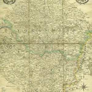
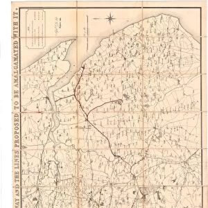
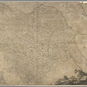
The Line of Railway from Sheffield to Manchester, as laid down in this map is the general line at present contemplated, subject to be altered when the surveys and levels shall be completed, 1831

![]()
Wall Art and Photo Gifts from Sheffield City Archives
The Line of Railway from Sheffield to Manchester, as laid down in this map is the general line at present contemplated, subject to be altered when the surveys and levels shall be completed, 1831
Scale 3.8 inches : 30 miles.Size 32 x 28 cm.Original at Local Studies A2S
Sheffield City Archives and Local Studies Library has an unrivalled collection of images of Sheffield, England
Media ID 14047877
© Sheffield City Council
FEATURES IN THESE COLLECTIONS
> Arts
> Artists
> P
> those present
> Europe
> United Kingdom
> England
> Manchester
> Manchester
> Maps and Charts
> Related Images
> Sheffield City Archives
> Maps and Plans
EDITORS COMMENTS
This print from Sheffield City Archives takes us back to the year 1831, offering a glimpse into the ambitious plans for railway development between Sheffield and Manchester. The map depicted here showcases the general line of this proposed railway, with an important caveat that it may be subject to alteration pending completion of surveys and levels. Measuring at 32 x 28 cm, this historical artifact provides valuable insights into the early stages of rail transport in England. Its scale is represented as 3.8 inches to every 30 miles, highlighting both the meticulous attention to detail and the vast distances covered by this transportation network. The significance of this photograph lies not only in its depiction of a specific route but also in its representation of progress and innovation during a transformative era. Railways were revolutionizing travel and trade across the country, connecting previously isolated communities while fostering economic growth. Preserved within Sheffield City Archives' Local Studies collection, this image serves as a reminder of our shared heritage and how far we have come since those pioneering days. It invites us to reflect on the visionaries who laid down these tracks over two centuries ago, paving the way for future advancements in transportation that continue to shape our world today
MADE IN THE USA
Safe Shipping with 30 Day Money Back Guarantee
FREE PERSONALISATION*
We are proud to offer a range of customisation features including Personalised Captions, Color Filters and Picture Zoom Tools
SECURE PAYMENTS
We happily accept a wide range of payment options so you can pay for the things you need in the way that is most convenient for you
* Options may vary by product and licensing agreement. Zoomed Pictures can be adjusted in the Cart.