Home > Europe > United Kingdom > Scotland > Aberdeenshire > Blackburn
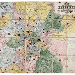
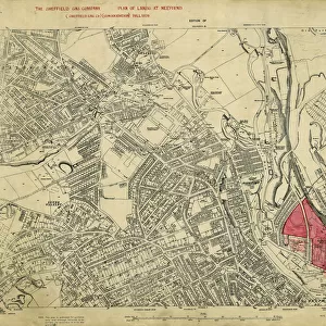
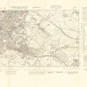
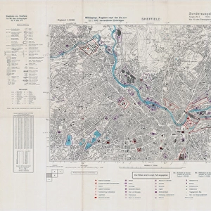
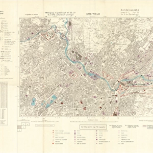
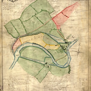
Ordnance Survey map of east end of Sheffield (and Rotherham) copied by the Germans, and marked with bombing targets
 copied by the Germans, and marked with bombing targets")
![]()
Wall Art and Photo Gifts from Sheffield City Archives
Ordnance Survey map of east end of Sheffield (and Rotherham) copied by the Germans, and marked with bombing targets
Original at Sheffield City Archives MD7731/2 and Sheffield Local Studies Librarys 26 M/2
Sheffield City Archives and Local Studies Library has an unrivalled collection of images of Sheffield, England
Media ID 14046610
© Sheffield City Council
Attercliffe Brightside Brown Centre Company East Firth Industry John Maps Power River Rotherham Stations Steel Tinsley Valley Wincobank Works World Blackburn Bombs Hadfields Hecla Lower Meadowhall Meadows Raids Richmond Supply
FEATURES IN THESE COLLECTIONS
> Europe
> United Kingdom
> Scotland
> Aberdeenshire
> Blackburn
> Europe
> United Kingdom
> Scotland
> West Lothian
> Blackburn
> Maps and Charts
> World
> Sheffield City Archives
> Maps and Plans
EDITORS COMMENTS
This print showcases an Ordnance Survey map of the east end of Sheffield, along with Rotherham, during a significant period in history - World War II. The Germans meticulously copied this map and marked it with bombing targets, providing a chilling glimpse into the strategic planning behind their air raids. The original document can be found at Sheffield City Archives (MD7731/2) and Sheffield Local Studies Library (26 M/2), serving as a testament to the importance of preserving historical artifacts. As we delve into this image, we are transported back in time to witness the impact of war on these industrial towns. The map highlights key locations such as Richmond, Meadowhall, Wincobank, Attercliffe, Tinsley, Brightside, Templeborough, Ickles - all areas deeply intertwined with steel industry giants like Hecla Works and Brown John Company. Firth Hadfields' presence is also evident along the River Don's lower valley. Notably captured are Blackburn Meadows Power Stations that played a crucial role in supplying electricity to these bustling centers. It is important to note that this information is solely for historical purposes and should not be used commercially. As we reflect upon this photograph print from Sheffield City Archives, let us remember the resilience and strength displayed by those who lived through these turbulent times while honoring their enduring legacy.
MADE IN THE USA
Safe Shipping with 30 Day Money Back Guarantee
FREE PERSONALISATION*
We are proud to offer a range of customisation features including Personalised Captions, Color Filters and Picture Zoom Tools
SECURE PAYMENTS
We happily accept a wide range of payment options so you can pay for the things you need in the way that is most convenient for you
* Options may vary by product and licensing agreement. Zoomed Pictures can be adjusted in the Cart.
![A map of the lands near Attercliffe and Darnall, [?1820s]](/sq/716/map-lands-near-attercliffe-darnall-1820s-18396317.jpg.webp)