Home > Arts > Artists > B > Emanuel Bowen
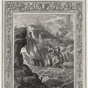
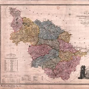
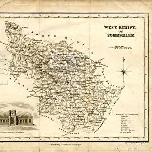
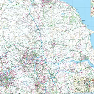
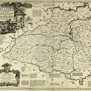
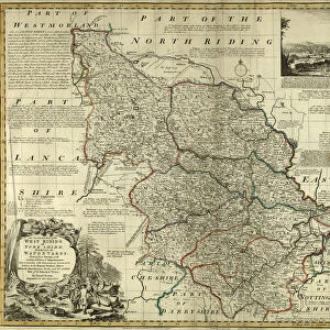
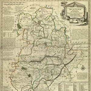
County Map of Yorkshire West Riding, c. 1777

![]()
Wall Art and Photo Gifts from Sheffield City Archives
County Map of Yorkshire West Riding, c. 1777
From The Large English Atlas: or, a new set of map of all the counties of England and Wales drawn from the several surveys which have been hitherto been published. With three general maps of England, Scotland and Ireland, from the latest and best authorities, by Emanuel Bowen, Thomas Kitchin and others. London, printed and sold by T. Bowles, [c.1777]
Original at Sheffield Libraries: 912 STF
Sheffield City Archives and Local Studies Library has an unrivalled collection of images of Sheffield, England
Media ID 25501551
© Sheffield City Council - All Rights Reserved
Antique Map Barnsley Bowens Map Bradfield Broomhall County Map Darnall Doncaster Ecclesfield Emanuel Bowen Heeley Old Map Owlerton Rotherham Sheffield Stannington Thomas Kitchin Tinsley Wadsley Wincobank Woodhouse Yorkshire Chapeltown Gleadless Halifax Handsworth Leeds Pontefract Shirecliffe Tickhill Wakefield
FEATURES IN THESE COLLECTIONS
> Arts
> Artists
> B
> Emanuel Bowen
> Arts
> Artists
> K
> Thomas Kitchin
> Europe
> Republic of Ireland
> Maps
> Europe
> United Kingdom
> England
> Leeds
> Europe
> United Kingdom
> England
> London
> Related Images
> Europe
> United Kingdom
> England
> Maps
> Europe
> United Kingdom
> England
> Sheffield
> Europe
> United Kingdom
> England
> Wakefield
> Europe
> United Kingdom
> England
> Yorkshire
> Barnsley
> Europe
> United Kingdom
> England
> Yorkshire
> Chapeltown
> Sheffield City Archives
> Maps and Plans
> Bowen's County Maps, c. 1777
> Sheffield City Archives
> Maps and Plans
> Maps of Yorkshire
EDITORS COMMENTS
This print showcases the "County Map of Yorkshire West Riding" from around 1777. The map is a part of "The Large English Atlas: or, a new set of maps of all the counties of England and Wales" which was meticulously drawn by renowned cartographers Emanuel Bowen, Thomas Kitchin, and others. This particular edition was printed and sold by T. Bowles in London. The map provides an intriguing glimpse into the past, offering a snapshot of Yorkshire's landscape during this era. It encompasses various notable towns and cities such as Halifax, Wakefield, Leeds, Tickhill, Sheffield, Ecclesfield, Barnsley, Doncaster, Rotherham, Pontefract and many more. From bustling urban centers to serene rural areas like Bradfield and Worral - every corner is intricately depicted. Sheffield Libraries proudly house the original copy of this antique map within their archives (912 STF). Its historical significance cannot be overstated as it offers valuable insights into the region's development over time. As you explore this remarkable piece of history through the lens of photography preservation at Sheffield City Archives; take note that commercial use is not permitted for this image. Nevertheless, let your imagination wander back to 18th-century Yorkshire while marveling at its rich cultural heritage captured within these intricate lines and detailed illustrations.
MADE IN THE USA
Safe Shipping with 30 Day Money Back Guarantee
FREE PERSONALISATION*
We are proud to offer a range of customisation features including Personalised Captions, Color Filters and Picture Zoom Tools
SECURE PAYMENTS
We happily accept a wide range of payment options so you can pay for the things you need in the way that is most convenient for you
* Options may vary by product and licensing agreement. Zoomed Pictures can be adjusted in the Cart.