Home > Sheffield City Archives > Maps and Plans > Sheffield OS maps
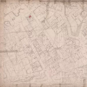
Ordnance Survey Map, Sheffield, Crookesmoor / Ponderosa area, 1889 (Yorkshire sheet 294. 7. 13)
")
![]()
Wall Art and Photo Gifts from Sheffield City Archives
Ordnance Survey Map, Sheffield, Crookesmoor / Ponderosa area, 1889 (Yorkshire sheet 294. 7. 13)
This map features:
Top left: Crookesmoor Road, Elliot Road, Burns Road, Barber Road, Vincent Road, Hadfield Hotel Public House, Moor Edge, Ivy Cottage, Oxford Street, St. Johns Wesleyan Chapel [on Crookesmoor Road], Manor View, Prospect Terrace, Post Office [on Crookesmoor Road].
Top right: Wentworth Street, Bromley Street, Canada Road, East Mushroom Lane, School playground [on Crookesmoor Road], Oxford Street, [The Ponderosa].
Bottom left: Crookesmoor Road, Great Dam Road, Old Great Dam [reservoir] Sheffield Waterworks), Harcourt Road, [Crookes Valley Road].
Bottom right: Bromley Street, Canada Road, East Mushroom Lane, Great Dam Road, Winter Street, Borough Fever Hospital [Winter Street Hospital], Westgrove Square.
Surveyed 1889. Reprinted 1901.
Dimensions of original: 77 x 102 cm.
Scale 10.56 feet : 1 mile [1:500].
From an original at Sheffield Libraries: q00057 (sheet No. 294.7.13)
Sheffield City Archives and Local Studies Library has an unrivalled collection of images of Sheffield, England
Media ID 25801119
© Sheffield City Council - All Rights Reserved
Old Map Ordnance Survey Os Map Sheffield
MADE IN THE USA
Safe Shipping with 30 Day Money Back Guarantee
FREE PERSONALISATION*
We are proud to offer a range of customisation features including Personalised Captions, Color Filters and Picture Zoom Tools
SECURE PAYMENTS
We happily accept a wide range of payment options so you can pay for the things you need in the way that is most convenient for you
* Options may vary by product and licensing agreement. Zoomed Pictures can be adjusted in the Cart.