Home > Europe > United Kingdom > England > Yorkshire > Healey
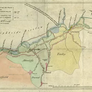
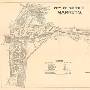
Plan of part of the markets in Sheffield, 1827

![]()
Wall Art and Photo Gifts from Sheffield City Archives
Plan of part of the markets in Sheffield, 1827
Full title: Plan of part of the town of Sheffield, comprising the site of the present and proposed corn, hay and cattle markets, also various improvements connected with the latter.
Woodhead and Hurst, architects, Doncaster.
Marked are: Market Place, Angel Street, Angel Inn, old corn market, King Street, post office, Change Alley, Kings Head, Fruit Market, Market Street, Norfolk Street, John Street, Commercial Inn, Hay Market, Yellow Lion, Pond Lane, Shude Hill, Fish Market, Dixon Lane, Tontine Inn, Castle Folds, Castle Hill, Healeys Hotel, Sheaf Bridge, River Sheaf, canal bridge, proposed Hay market, proposed Corn Market, Broad Street, Canal Basin, Canal Warehouse, market for fat cattle, lean cattle and milch cows, pig market, sheep market, River Dun [River Don], Willey Street, Blonck Street, Wicker, Cattle Market, Ladys Bridge, Bridge Street, Wain Gate, Town Hall, Killing Shambles and Castle Street.
From an original at Sheffield Librarires: arc04182
Sheffield City Archives and Local Studies Library has an unrivalled collection of images of Sheffield, England
Media ID 24293929
© Sheffield City Council - All Rights Reserved
FEATURES IN THESE COLLECTIONS
> Animals
> Farm
> Cattle
> Related Images
> Animals
> Fishes
> Related Images
> Animals
> Mammals
> Bovidae
> Cattle
> Animals
> Mammals
> Bovidae
> Sheep
> Animals
> Mammals
> Cats (Wild)
> Lion
> Arts
> Artists
> P
> those present
> Europe
> United Kingdom
> England
> Norfolk
> Related Images
> Europe
> United Kingdom
> England
> Yorkshire
> Doncaster
> Europe
> United Kingdom
> England
> Yorkshire
> Healey
> Europe
> United Kingdom
> England
> Yorkshire
> Sheffield
> Sheffield City Archives
> Maps and Plans
> Maps of Sheffield
EDITORS COMMENTS
This print from 1827 showcases the intricate "Plan of part of the markets in Sheffield". The detailed illustration, created by Woodhead and Hurst, architects from Doncaster, offers a fascinating glimpse into the bustling town during that era. The plan highlights various landmarks and streets that were integral to Sheffield's market scene. Market Place takes center stage, surrounded by Angel Street and its namesake inn. Other notable locations include King Street, post office, Change Alley, Fruit Market, Norfolk Street, Commercial Inn, Shude Hill, Fish Market, Tontine Inn - each playing a vital role in shaping the city's vibrant trading atmosphere. The image also reveals proposed additions to further enhance Sheffield's market infrastructure. Plans for a Hay market and Corn Market are marked on the map alongside Canal Basin and Canal Warehouse – symbols of industrial progress at that time. Notably captured are specific areas designated for different livestock markets such as fat cattle, lean cattle and milch cows; pig market; sheep market; all strategically placed near River Sheaf and River Dun (River Don). This arrangement reflects both practicality and convenience for traders who relied heavily on waterways for transportation. Preserved within Sheffield Libraries' archives (arc04182), this historical gem provides an invaluable window into the past while reminding us of the city's rich commercial heritage.
MADE IN THE USA
Safe Shipping with 30 Day Money Back Guarantee
FREE PERSONALISATION*
We are proud to offer a range of customisation features including Personalised Captions, Color Filters and Picture Zoom Tools
SECURE PAYMENTS
We happily accept a wide range of payment options so you can pay for the things you need in the way that is most convenient for you
* Options may vary by product and licensing agreement. Zoomed Pictures can be adjusted in the Cart.